|
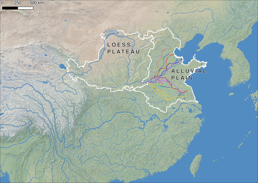
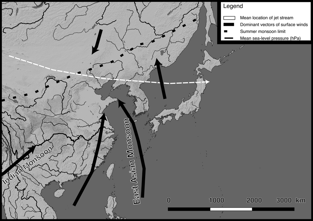
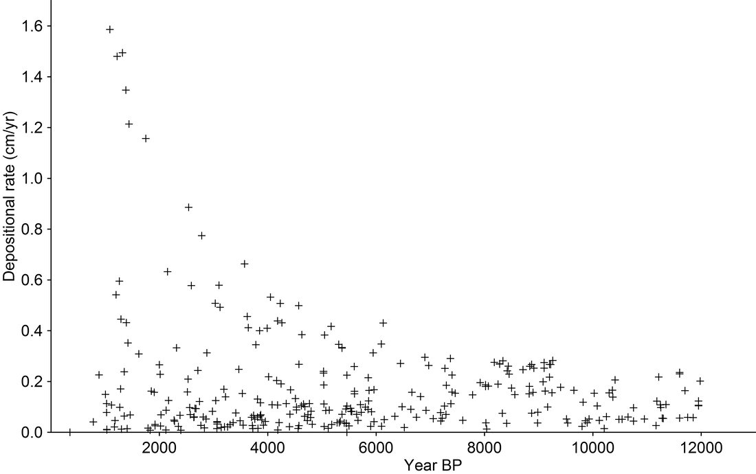
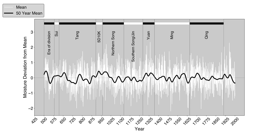
Ruth Mostern, University of Pittsburgh A river is not simply a tidy channel of water traversing dry land. It is a complex system that carries organic and mineral material out of higher altitude locations and deposits them on a floodplain or estuary.[1] The Yellow River, situated near the northern perimeter of the East Asia Summer Monsoon, is currently the most sediment laden river in the world. It carries sediment from the Loess Plateau, located primarily northwestern China, and deposits it on the North China Plain. The process of sediment deposition, which accelerated during historical times, increased by an order of magnitude about a thousand years ago and continued to rise thereafter. Whenever Loess Plateau population became denser and settlements became more numerous, especially on the most fragile and arid northern periphery of the region, erosion increased. That transpired primarily in periodic events of settler colonialism and military fortification. Whenever people began to exploit the Loess Plateau more intensively, the alluvial plain grew more prone to flooding, and hydroengineering interventions became more critical. Historically, decadal and centennial climate variations, and even annual weather variations, rarely correlate to flood rates. That is because human activity (upstream farming and settlement, and downstream flood control initiatives) had such an overwhelming influence on flood frequency. However, climate history is indirectly important for understanding Yellow River history, because climate variations strongly influenced geopolitics on the Loess Plateau, and climate variations shaped the range of possibilities available to generals, colonists, and denizens there. During moist years, populations grew and spread out, landscapes supported settlers and soldiers alike, and farming, grazing, and timbering accelerated erosion. During droughts, farmers, herders, hunters, and animals crowded onto smaller habitable territories. The resulting social friction caused political conflict and prompted fortification, but on the other hand, dry conditions constrained populations and the erosion that they caused. In short, although climate history is significant, it does not determine any single outcome in the history of the Yellow River at the scale of the longue durée. For example, as Figure 4 reveals, much of the Tang era (618-907 CE) transpired during a period of extremely dry climate. There is no direct causal link between drought and the stability of nomadic societies, but drought conditions plausibly explain why various steppe and Tibetan states sought to take sides in the massive 755 An Lushan Rebellion and how they played a role in the series of events that caused sovereignty in north China to splinter between competing warlords and rival claimants for imperial thrones thereafter.[4] The middle and upper courses of the Yellow River became sites of frequent battles, repeated fortification initiatives, refugee migrations, and competing waves of military and civilian colonization. Erosion began to rise rapidly. Conversely, moist conditions on the Loess Plateau were also politically destabilizing at times. In 960, near the beginning of a lengthy moist period, a new regime known as the Song (960-1276) unified much of former Tang territory. The Song rulers did not succeed in recolonizing the northwestern part of the Loess Plateau. That region remained in the hands of a rival people, the Tanguts, who established a regime known as the Xi Xia (1038-1227) and founded a capital on the banks of the Yellow River. Climate conditions permitted both sides to settlements at an unprecedented density. Hundreds of thousands of troops and allied civilians on both sides of the border confronted one another across a heavily fortified frontier. A commercial timber market arose around the same time. This, too, created conditions that caused erosion to rise exponentially. The Song regime lost control of north China in 1127, during a time of rapidly fluctuating moist and arid cycles. For more than two centuries thereafter, the entire Yellow River basin lay in the hands of sovereigns who did not fortify a border on the Loess Plateau and who did not encourage intensive agriculture there. For reasons of geopolitics, and not climate, erosion rates diminished. However, the next episode of rising erosion implicated climate once again. Deep and lengthy drought during the second half of the fifteenth century upended politics on the Loess Plateau. By the middle of the century, Mongol detachments had moved into the region: mounted warriors, but also groups of herders seeking water and pasture during an era of scarcity. At the Chinese Ming court, advocates for a fortification strategy spoke of fertile fields, rich soil, and abundant salt lakes that still persisted on the Loess Plateau. They succeeded in fostering a policy of building garrisons and moving in settler colonist farmers even in the midst of the drought. This was the origin of the well-known Great Wall. The demands of military colonization outstripped the carrying capacity of the land even when rainfall was good. A century later, even though precipitation was above average, the region along the military frontier deteriorated into desert. One observer attributed this to deforestation that resulted from farming, firewood collection, and brick making to repair the wall and to construct new buildings.[5] Environmental scientist Jianxin Cui and his coauthors assert that climate played the primary role in desertification and the Ming retreat from the frontier.[6] However, fluctuations in precipitation do not match neatly to historical records that report about landscape deterioration nor to the history of civilian and military colonization. For many decades, the predominant factor in the Ming retreat from the desert edge was intensive human exploitation of an agriculturally marginal landscape. Ultimately, however, catastrophic drought did contribute to the desertification that shuttered the most northerly settlements and garrisons in the early seventeenth century. Between 1566 and 1620, yields on military farms dropped by 60 to 70 percent. As the loess environment deteriorated, soldiers began to flee or mutiny, and civilian farmers rebelled as well.[7] After the fall of the Ming regime, when populations rebounded with moist climate conditions in the eighteenth century, they were civilian farmers incentivized by favorable tax policies whose farming and timbering caused erosion to increase once again. It is possible to tell a climate story about the last fifteen hundred years of Yellow River history, where wet and arid conditions succeeded one another at the monsoon periphery. However, that history does not map neatly onto the narrative of erosion on the Loess Plateau. It explains flooding on the alluvial plain even less well. Erosion sometimes accelerated during arid epochs that fostered political conflict over access to the grasslands and forests of the region. It also rose during certain moist periods that supported large populations of farmers, herders, and lumbermen. The history of the Yellow River is an exemplary case for understanding the complexity of climate history. [1] This article is adapted from my forthcoming book Yu’s Traces: The Natural and Unnatural History of the Yellow River (Yale University Press, 2021). Thank you to Ryan M. Horne for his assistance with data analysis and cartography and infographic design.
[2] Shi Changxiang, Zhang Dian and Lianyuan You, “Changes in Sediment Yield of the Yellow River Basin of China During the Holocene,” Geomorphology 46.3-4 (2002), 267-283. [3] Cook, E.R., K.J. Anchukaitis, B.M. Buckley, R.D. D'Arrigo, G.C. Jacoby, and W.E. Wright, “Asian Monsoon Failure and Megadrought during the Last Millennium. Science, 328 (2010), 486-489. (Monsoon Asia Drought Atlas) [http://drought.memphis.edu/MADA/Default.aspx]. Thank you to Amy Hessl for communicating with me about this data and for agreeing to share it with me. [4] Nicola Di Cosmo, Amy Hessl, Caroline Leland, Oyunsanaa Byambasuren, “Environmental Stress and Steppe Nomads: Rethinking the History of the Uyghur Empire (744-840) with Paleoclimate Data,” The Journal of Interdisciplinary History 48.4 (2018), 439-463. [5] Gu Zuyu et al., Dushi fangyu jiyao (Beijing: Zhonghua shuju, 2019 [1630-1660]), j. 61. [6] Jianxin Cui, Hong Chang, Kaiyue Cheng and George Burr, “Climate Change, Desertification and Societal Responses,” Weather, Climate, and Society 9.1 (2017), 81-94: 81. [7] Cui et al, “Climate Change, Desertification and Societal Responses,” 91.
32 Comments
|
Archives
August 2021
Categories |


 RSS Feed