|
Dr. Dagomar Degroot, Georgetown University 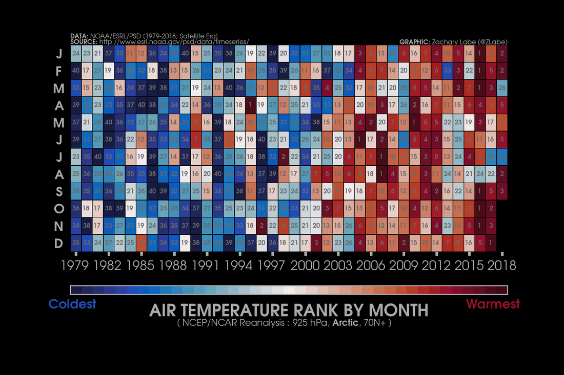 Seasonal air temperatures across the Arctic are warming fast. NSIDC International climate change agreements have long aimed at limiting anthropogenic global warming to 2°C Celsius, relative to “pre-industrial” averages. Yet in early 2015, more than 70 scientists contributed to a report that warned about then-poorly understood dangers of warming short of 2° C. Several months later, Parties to the United Nations Framework Convention on Climate Change (UNFCCC) met in Paris and reached what seemed to be a promising agreement that aimed at keeping global warming to “well below” 2° C. The Paris Agreement invited the Intergovernmental Panel on Climate Change (IPCC) to prepare a special Assessment Report on the consequences of, and means of avoiding, warming on the order of 1.5° C. The IPCC accepted the invitation in 2016. This week, it published its report, together with a short summary for policymakers. In it, 91 scholars from 40 countries summarize the results of more than 6,000 peer-reviewed articles on climate change. The published report still captured headlines and provoked justified alarm. Here’s what struck me as I read through it this week. 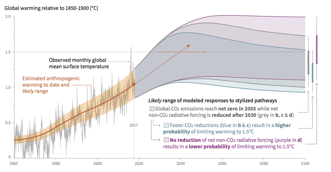 An IPCC graphic shows that if greenhouse gas emissions continue unabated, Earth's temperature will likely cross the 1.5° C threshold by 2040. Just 40 years from now. The Importance of 0.5° CThe new assessment report is really all about half a degree Celsius. Since the world has now warmed by roughly one degree Celsius since a 1850-1900 baseline, only half a degree Celsius separates us from 1.5° C of warming, which in turn is of course only half a degree removed from the infamous 2° C threshold previously emphasized by the IPCC and the UNFCCC. So, what difference does 0.5° C make? It depends on the perspective you take. The new report shocked many by predicting that some of the profound environmental transformations long anticipated with 2° C warming, relative to the nineteenth-century baseline, would be well underway with just 1.5° C warming. By 2100, for example, sea levels could rise by up to 0.77 meters if temperatures increase by no more than 1.5° C, which may only be around 0.1 meters lower than the level they would reach with 2° C warming. Worse, it now seems that marine ice cliff instability in Antarctica and the irreversible collapse of the Greenland ice sheet – two frightening scenarios that could each raise global sea levels by many more meters and set off additional tipping points in the climate system (see below) – could be triggered by just 1.5° C warming. Perhaps 90% of the world’s coral reefs could be lost with 1.5°C warming, compared to every reef in a 2° C world. In one sense, there seems to be a huge gulf between where we are now and where we’d be with another half-degree of warming, and comparatively little difference between a 1.5° C and a 2° C world. Yet in other, critically important ways, there could be an equally big gap between the 1.5° C and 2° C scenarios. Of 105,000 species considered in the report, three times as many insects, and twice as many plants and animals, would endure profound climatically-determined changes in geographic range in a 2° C world, relative to a 1.5° C world. A threefold increase in the terrestrial land area projected to change from one ecosystem to another also seperates the 1.5° C and 2° C worlds. The importance of just half a degree Celsius is particularly clear at local and regional scales. Warming is greater on land than at sea, and much greater across the Arctic. In cities, urban heat islands double or even treble global warming trends. In many regions, extreme weather events – droughts, torrential rains, heat waves and even cold snaps – are now much more likely to occur than they once were. Superficially modest trends on a global scale can mask tremendous shifts in local or regional weather. The critical importance of warming on the order of just half a degree Celsius for ecosystems around the world invites us to revisit some of the more controversial claims made by climate historians about the environmental impacts of past climate change. There is, of course, a range of natural climatic variability that most ecosystems can accommodate, and we are on the verge of leaving that range across much of the Earth, if we have not left it already. Yet it now seems painfully clear that even small fluctuations in Earth’s average annual temperature can have truly profound ramifications for the regional or local ranges and life cycles of plants, animals, and microbes. 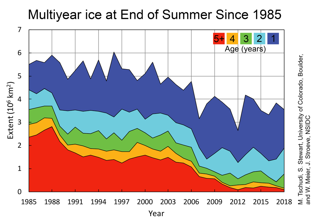 Even today, older ice is all but gone in the Arctic. NSIDC Risk, Uncertainty, and ScaleBack to the difference between 1°, 1.5°, and 2° C warming. Perhaps the most alarming part of the new assessment report – one seemingly lost on many environmental journalists – is what it says about the value of the whole project of establishing numbers that become touchstones in climate change discourse. Beginning well before 2015, climate scholars pointed out that attempts to emphasize the danger of 2° C warming risked creating the false impression, among policymakers and the public, that the worst impacts of climate change would suddenly unfold only after Earth passed that threshold. I’d wager that for most people, the 2° C limit still seems like a distant threat, one we will eventually face only if we don’t gradually reduce greenhouse gas emissions. Yet the new report confirms that the 2° C threshold was all along an arbitrary standard, one that did not really convey the nature of the threat we face. It is now plain that we will not only trigger vast and irreversible changes to Earth’s climate system with 1.5° C warming, but worse: we have already engaged some of them, and we may unlock more in coming years. Nature, unfortunately, cares little for our nicely rounded numbers. There’s more. Even before its release, some climate scientists and activists criticized the new report for understating the extent of present-day warming, and more importantly: ignoring the so-called “fat tail” threat of runaway warming triggered by positive feedbacks, or “tipping points,” buried within the climate system. Of these feedbacks, the best known is probably the ice-albedo feedback, where modest warming melts bright sea ice that normally bounces sunlight back into space, replacing it with dark water that absorbs solar radiation, contributes to more warming, more melting, and so on. Another well-known feedback involves methane that now lies buried in Arctic permafrost and frozen seabed sediment. Warming is already melting tons of methane into the atmosphere, where it traps far more heat than carbon dioxide. Again: warming will lead to more melting, more warming, and so on. These feedbacks have historically converted relatively minor sources of warming or cooling into profound climatic trends. Yet scientists don’t know precisely how all such feedbacks work, or when exactly they are triggered. If we’re lucky, we won’t trigger most of them at all, not even if we reach that 2° C threshold. Yet it’s also possible that we have already set some of them in motion, in ways that will irreversibly lead us to runaway warming. In that case, our children – or our children’s children – will have to survive a “hothouse” world, one fundamentally different from our own. This brings us back to the issue of risk and probability, which the IPCC’s scientists stress in every assessment reports. The IPCC expresses uncertainty using the terms “confidence” and “likelihood,” and it is very important to decode these terms in order to understand the new assessment report. In it, the terms “very low,” “low,” “medium,” “high,” and “very high” confidence all refer to the confidence the report authors have in key findings. Their level of confidence reflects both the quality, quantity, and type of evidence used to support those findings, and the extent to which different lines of evidence agree with the findings. In the report, the terms “exceptionally unlikely,” “extremely unlikely,” “very unlikely,” “unlikely,” “about as likely as not,” “likely, “very likely,’ and “extremely likely” all refer to the statistical probability of outcomes actually happening, based in part on the findings. Unfortunately, these definitions are buried on page 40 of the first chapter of the new assessment report. Yet they make it impossible to conclude, as so many journalists have written, that the new report predicts what will happen in the future. Using such language plays into the hands of climate change deniers, who rightly point out that nobody can predict the future with certainty. Climate scientists, of course, know that better than most, which is why they always attempt to qualify and quantify their predictions. Climate historians also deal with probability. As I point out in a forthcoming article, we can never really reconstruct the local or regional manifestations of climate change with perfect certainty, nor can we be completely sure of local connections between climatic trends and human or animal behavior. Some of the most interesting relationships we can discern are among the least documented, especially once we get away from the usual European or Chinese focus of most climate historians. At its best, climate history therefore deals explicitly with risk and uncertainty by qualifying its major findings. Other historians tend to rebel against such qualifiers. More than one peer reviewer, for example, has told me to be more authoritative, to forcefully express that climate change directly caused humans to do something in the past. To these historians, qualifiers communicate the kind of weak uncertainty that seems to suggest that an argument is not well grounded on solid scholarship. These criticisms come from the practice of traditional historical scholarship, where documents seem to communicate exactly what happened to whom, and when. Yet when we work with different kinds of sources, from natural archives, those relationships cannot always be clearly or simply established. The more, and more diverse, information you have, the more uncertain the past can become. Still, abundant information from many natural and human sources can also provoke questions, and suggest relationships, that traditional historians have not imagined. The best documented and seemingly most certain version of the past, in other words, isn't always the most accurate. 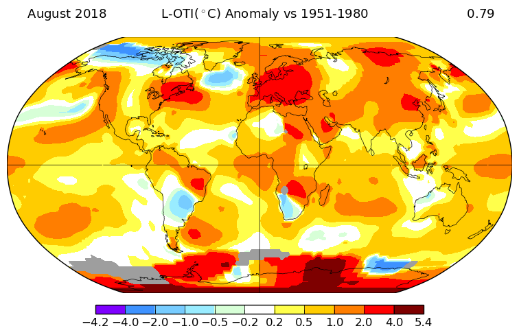 Global temperature anomalies in August, relative to the 1951-1980 mean. NASA GISS A Determined Future (and Past?)The new IPCC report also abounds with exactly the kind of sweeping statements that historians – myself included – have attacked in the past. In a brilliant 2011 article I often ask my students to read, Mike Hulme criticizes how the predictive natural sciences have promoted a new variant of the climate determinism many Europeans once used to explain the expansion of western empires. Because climate change can be predicted more easily than social change, Hulme argues, climate science has promoted a kind of climate reductionism that “downgrades human agency and constrains the human imagination.” Surely, the human future will not be crudely determined by climatic trends. And yet, the IPCC concludes that climate change will probably exacerbate poverty, provoke catastrophic migration, impede or annihilate economic growth, amplify the risk of disease, and, in short, sharply undermine human wellbeing, especially for “disadvantaged and vulnerable populations, some indigenous peoples, and local communities dependent on agricultural or coastal livelihoods.” While there will be ways for communities and societies to adapt, the IPCC’s summary for policymakers finds that “there are limits to adaptation and adaptive capacity for some human and natural systems” in even a 1.5° C world. Warming, in short, will likely provoke human suffering. Should we be skeptical of such claims? As usual: it’s complicated. While historians like to emphasize complexity and contingency in narratives of the past, scientists search for patterns in complex systems that permit predictive models. Many historians therefore feel uncomfortable when asked to anticipate the future in light of the past, and that discomfort is partly to blame for the unfortunate absence of historical scholarship in the new assessment report. Of course, scientists have no such problem. Their models can indeed be deterministic – by necessity, they only consider so many variables – yet they still provide some of our best perspectives on what the future might have in store. With that said, it's important to again stress that many of these models should be taken as estimates of what might happen in our future. They cannot tell us what will actually unfold. History does teach us that the human story involves both steady trends and sudden leaps: technological breakthroughs, revolutions, and the like. It is simply wrong to conclude that even 2° C warming will make the world a more impoverished, more violent place, as some assume. Older predictions of “peak oil,” for example, or a “population bomb” have not (yet) come to pass, partly because individuals and institutions responded creatively, on many different scales, to menacing trends. The new assessment report actually describes the kind of action that would help state and non-state actors confront the challenge of climate change (spoiler alert: it’s not geo-engineering). People are not passive, static victims in the IPCC’s assessment, as they tend to be in reductionist literature. Yet even if the wise policies recommended by the IPCC are ignored, we cannot predict or quantify exactly what the future has in store for humanity. But now, back to those controversial claims made by climate historians. Critics have accused some of the more ambitious books in climate history – authored by the likes of John Brooke and Geoffrey Parker, for example – of crude determinism for suggesting that past climatic fluctuations on the order of just half a degree Celsius unleashed disaster for societies around the pre-modern world. Indeed, some calamities that climate historians have blamed on climate change had many alternate or additional causes, and most coincided with examples of communities and societies successfully weathering climate change. Yet the scale of social disruption predicted by the IPCC in a world just a little warmer than our own does invite us to consider whether the fates of pre-industrial societies were not more closely connected to climatic trends than most historians and archaeologists have allowed. Both environments and societies, in other words, seem more vulnerable to even slight climatic fluctuations than we had imagined. 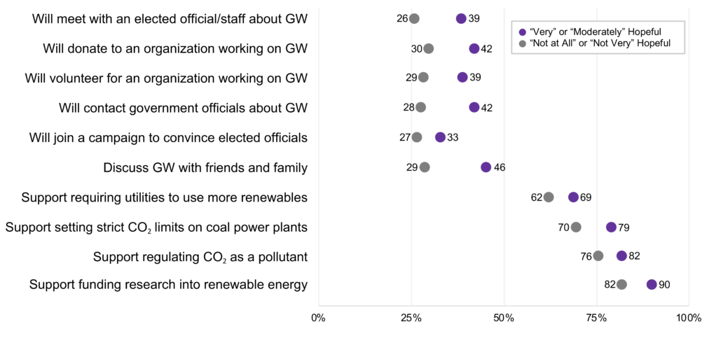 Does hope drive action on global warming? Numbers represent the percentage of those who were hopeful (purple) and not hopeful (grey) about global warming. Yale Program on Climate Change Communication. The Popular ResponseIn the wake of the new report, articles in popular media and discussions in social media have predictably focused on how its findings should be communicated. Should climate communicators try to drum up fear, or should be we inspire hope? Hope does seem to be more useful emotion in motivation public engagement on global warming. Yet recently, many scholars have actually moved beyond this question. A 2017 article in the journal Nature, for example, concludes that climate change messages should be carefully calibrated to their audience. Neither hope nor fear will motivate everyone; in fact, a catchall message that relies on either emotion will likely provoke the opposite of the desired response in a sizable part of the population. This is hardly surprising: political operatives and advertisers have known for years that the best messages are highly targeted. Some news articles have stressed what individuals can do in order to lower their personal carbon emissions. Many scientists and environmentalists have responded by arguing that only government policy can begin to address climate change on the scale we need. By stressing personal accountability, some argue, journalists shift attention from the real climate culprits: the big corporations and well-funded political interests with a stake in the fossil fuel economy. As in most such debates, both sides have valid points. Clearly, we should all aim to limit our emissions while at the same time becoming politically motivated as never before. We will need to fundamentally transform our economy and our politics – quickly! – if we are to confront the challenge of climate change. How we do this, and what it will mean for us personally, is something all of us will need to sort out soon. Those of us who have chosen to remain above the political fray will need to re-evaluate that decision. Some of the first news articles about the IPCC's new report included commentaries on the need for journalists to make climate change the biggest story they cover. I wrote an article to that effect during the 2016 election, and sent it to the editors of the New York Times. Predictably, there was no response. And now, even in the wake of hurricane Michael’s rapid intensification and calamitous landfall, climate change has already moved off the front pages of many newspapers. Politicians in the United States and elsewhere have already brushed off the IPCC’s urgent warnings. One wonders: will the new report really change anything? Or will the capitalist dynamics behind our media outlets and political processes derail the changes we so urgently need to make? Ultimately, it’s clear that nobody and nothing will rise to save us from our fate. Those of us who understand the science behind climate change need to do more than communicate. Now, we need to actively be part of the solution. We need to act. Recommended ReadingDr. Dagomar Degroot, Georgetown University  Can correlating climatic and social variables tell us more about the human costs of climate change? Until recently, it was notoriously difficult to connect today’s extreme weather with the gradual trends of climate change. Scientists shied away from saying, for example, that catastrophic droughts or severe hurricanes reflected the influence of anthropogenic global warming. Yet today, scientists use big data from satellites and weather stations to inform supercomputer simulations that reveal the extent to which warming trends have raised the odds for previously unusual weather. Scientists now report, for instance, that the drought that crippled Syria between 2006 and 2009 was between two and three times more likely in today’s climate than it would have been a century earlier. They feel comfortable concluding that the rains of Hurricane Harvey were perhaps 20 times more likely now than they once were. Armed with these statistics, many scholars and journalists now conclude that events like the Syrian Civil War, which unfolded in the wake of that devastating drought, can be convincingly connected to climate change. Yet how can we link past climate change – change that happened before the advent of big weather data – to human affairs? Many historians and archaeologists favor qualitative methods. They identify weather events in surviving documents, or in paleoclimatic proxy data (such as tree rings, ice cores, or lakebed sediments) that register the influence of temperature or precipitation. Next, they carefully study texts or ruins to determine how these weather events influenced human activities – such as farming, hunting, or sailing – that clearly depended on favorable weather. By looking at enough of these relationships, over a long enough timeframe, they ultimately reach conclusions about the influence of weather trends – that is, climate change – on the human past. Environmental historians might be most familiar with these qualitative methods. They inform a raft of new books and articles in climate history, on diverse topics that range from the fall of Rome to the colonization of Australia; from the origins of apocalyptic Norse mythology to the travails of Arctic whalers.  A selection of recent books on climate history, all written by historians. But these qualitative methods are much less influential beyond the historical profession. Today, there is a large and rapidly growing “quantitative” school of climate history that instead relies on statistical means to discern the impact of climate change on human history. Papers in this school are cited more frequently in the latest IPCC assessment report, for example, than publications written by historians who prefer more qualitative means of doing history. Natural scientists, economists, and historical geographers in the quantitative school of climate history quantify diverse social variables in particular regions, then graph their highs and lows over decades, centuries, even millennia. Next, they develop or make use of temperature or precipitation reconstructions for those same regions across identical timescales. Finally, they use statistical methods to find covariance between their graphs of social and climatic trends. Most published work in this vein finds statistically significant correlations between these trends. In study after study, Chinese historical geographers have found striking correlations between climatic cooling and the wars, rebellions, and dynastic transitions of Imperial China. European scholars have found equally impressive correlations between cool, wet conditions and conflict in northwestern Europe over the past five centuries. In southeastern and central Europe, by contrast, correlations exist between conflict and warm, dry weather. Another, even more ambitious study finds strong correlation between European wars and climate changes over 2,600 years. Quantitative climate historians often focus on China and Europe, and not only because most of them live in these regions. People across much of China and Europe have long relied on rain-fed agriculture, which should have been especially sensitive to fluctuations in temperature or precipitation. They also kept unusually detailed, and unusually continuous, records of their activities. Yet a growing group of quantitative researchers now concentrates on the much more recent history of sub-Saharan Africa, where millions continue to rely on rain-fed agriculture. Many studies correlate warming, drying trends across Africa to twentieth-century civil wars, although some emphasize that these correlations only existed under the right socioeconomic conditions. The great appeal of quantitative approaches to climate history is that they seem to replace the messiness of the historian’s craft, and the subjectivity of the qualitative findings, with scientific objectivity and certainty. Quantitative historians have used statistical correlation not only to confidently explain the past, but also to predict the future. Already in 2007, historical geographers concluded, for example, that Chinese “war-peace, population, and price cycles in recent centuries have been driven mainly by long-term climate change.” Two years later, another group controversially concluded that the frequency of civil wars in sub-Saharan Africa would likely increase as the continent warmed, since a regional correlation between temperature and violence existed in the past.  An IPCC projection of average global temperatures in 2081-2100, relative to late twentieth-century averages, under a moderate emissions scenario. Will a warmer Earth be a more violent place? But have quantitative scholars really found a better way of doing climate history, one that at last permits predictions of the kind that always remain frustratingly out of reach for historians and archaeologists? Well, not quite. On close examination, the soaring claims made by many quantitative scholars in fact rest on assumptions that remain frustratingly subjective . . . and at times, simply misguided. Most importantly, the correlations identified in quantitative work are meaningless unless their trends reflect the right data. Some studies of this kind use weather observations in surviving documents to graph centuries-long trends in temperature or precipitation. Decades ago, the great meteorologist Hubert Lamb relied on much the same method to identify a hot climatic regime that he called the “Medieval Warm Period.” The medieval centuries, Lamb concluded, were at least as warm as the late twentieth century. While some deniers of anthropogenic global warming still use Lamb’s graph, scholars have changed the name of his period to the “Medieval Climate Anomaly.” It turns out that Lamb, unversed in the art of reading historical sources, simply took medieval references to weather at face value. When the legitimate weather observations examined by Lamb are read more carefully, and used alongside climate reconstructions compiled with more reliable tree ring or ice core data, they reveal a period of modest but erratic warming in the high medieval centuries. Nothing comparable, in other words, with late twentieth-century warming. The lesson here is that references to weather in ancient documents do not always simply reveal the state of the atmosphere in a particular time and place. The problem is much more acute when considering very long timescales. Before the instrumental era, even seemingly reliable weather observations over decades or centuries are really the product of many observers, some of whom might use different methods to record weather. Moreover, sources that may seem especially dependable at a glance – such as many European chronicles – in fact refer to weather metaphorically, or use fabricated weather events to justify the course of human affairs. Researchers should therefore strive to use weather observations in historical documents as a starting point – only a starting point! – in a long process of reconstructing a region’s climate. Where possible, documentary evidence should be used alongside climate reconstructions compiled with tree rings, ice cores, lakebed sediments, and the many other proxy sources in natural archives. The best climate reconstructions often use the most proxies. Of course, many excellent reconstructions have now been published for most parts of the world. There is often little need to develop a regional climate reconstruction from scratch. In quantitative climate history, multi-proxy climate reconstructions should also reveal climatic trends on the same spatial scale as the social variables under consideration. Even some scholars who do use so-called “multiproxy” climate reconstructions to find their correlations go on to match trends of global or hemispheric temperature or precipitation with trends of local or regional historical events. Yet before the onset of anthropogenic global warming, climatic trends rarely unfolded at the same time in every part of the globe. A general cooling trend across the northern hemisphere, for example, did not always lead to colder temperatures in China. If quantitative climate historians face problems when choosing which climate reconstructions to use – or how to make them – these pale in comparisons to those that bedevil their attempts to quantify social variables. Quantitative studies of war, for example, have used makeshift and now defunct websites to determine when wars began and ended. Others have relied on historical scholarship that is well over a century old. It is as though the historical geographers, political scientists, natural scientists, and economists who typically write quantitative climate history do not recognize that the disciplines of history and archaeology are as rigorous and dynamic as their own. Naturally, correlations that rely on obsolete or untrustworthy data about the human past can tell us little about the influence of climate change on human history. Jan de Vries, Philip Slavin, and I have also flagged a second big problem faced by quantitative approaches to climate history. Studies that find correlations over centuries, let alone millennia, rarely appreciate that social variables change through time. A statistically significant correlation between warming and economic growth in the high medieval centuries, for example, does not necessarily hint at the same kind of relationship between climate change and human affairs as a similar correlation several hundred years later. Over the course of those centuries, the cultural, economic, social, and political pathways by which climate change affects human life may have fundamentally changed, and the individuals who control those pathways will have obviously died. The question becomes: what are quantitative approaches to climate change really measuring? That gets us into a third, and related, problem of quantifying the human past. It is one thing to quantify a particular kind of agricultural production over long timespans. Though agricultural practices can change dramatically over those timespans, even in pre-modern societies, scholars may still find correlations between agricultural yields and climatic trends that can suggest something new about the human past. Yet it is quite another matter to quantify the number or intensity of a major social event, such as a war. Attempts to link the number of wars by decade to decadal temperature or precipitation, for example, face the challenge of quantifying long and complex wars: precisely the kind of war that often placed the greatest strain on agricultural resources also affected by climate change. Scholars might consider the Thirty Years’ War, for instance, as either a single war or a series of wars, and their subjective choice would determine the correlation identified in a study between seventeenth-century climate change and European conflict. In some of these studies, the early seventeenth century may look like a time of relative peace in Germany! Scientists have also used arbitrary numbers to decide when violence amounts to a war. Does violence rise to the status of war when at least 1,000 people have died, as some studies assume? Presumably the standard would be higher in very populous societies and lower in less populated ones, but this distinction is never made in quantitative studies. Graphing wars by quantity can also lead scholars to misrepresent changes in quality. Scholars might easily count the First and Second World Wars as only two wars, for example, yet of course their material and human costs dwarfed those of any previous conflict. If problems of this nature plague the superficially simple task of correlating the number of wars to temperature trends, imagine the challenges of determining similar correlations with, for example, economic development or cultural efflorescence! 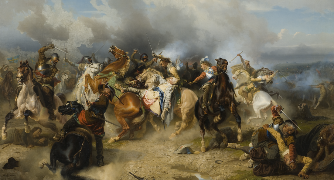 A nineteenth-century imagining of the death of Gustavus Adolphus, a turning point in the Thirty Years' War. How should quantitative climate historians make sense of particularly long, bloody wars? Carl Wahlbom, "Death of King Gustav II Adolf of Sweden at the Battle of Lützen." Nationalmuseum, 1854. It turns out that quantitative approaches to climate history often obscure more than they reveal. Far from providing a more objective, “scientific” way of understanding the impact of climate change on the human past, they really rely on assumptions that are every bit as subjective as those made in more qualitative work. Yet unlike many qualitative climate historians, they leave those assumptions unacknowledged. I am convinced that quantitative climate historians could fruitfully address at least some of these problems by interacting more with qualitative scholars, most of whom work in the humanities. Unfortunately, many historians, at least, have not heard of quantitative approaches to climate history, while most quantitative scholars have little inkling of qualitative approaches to their subject. Remarkably, I have never seen a work of qualitative climate history cited within a paper that aims to identify correlation. Part of the problem is that quantitative and qualitative scholars often work in different media. While historians prioritize books, most scientists, economists, and geographers value short, multi-authored studies. Yet collaboration is surely possible, and if so it would undoubtedly prove productive. Quantitative scholars have recently used statistical means to identify not only how climate change might be correlated to human activities, but also how it might have partly accounted for – that is, caused – those activities. Such studies have yielded models that are really variants of models that qualitative scholars had already developed. What if they had worked with qualitative scholars from the start? Meanwhile, qualitative scholars often use statistics to support their conclusions, without always understanding what those statistics actually reveal (or what they don’t). What if qualitative scholars consulted colleagues in more quantitative disciplines while developing these statistics? At the Climate History Network, we will strive to incorporate more quantitative scholars within our ranks. Perhaps we will be able to build a shared community in the coming years, one that will yield a more comprehensive kind of climate history. Works Cited:
Buhaug, Halvard. “Climate not to blame for African civil wars.” Proceedings of the National Academy of Sciences 107:38 (2010): 16477-16482. Büntgen U. et al. “2500 years of European climate variability and human susceptibility.” Science 331:6017 (2011): 578-582. Burke, Marshall B. et al. “Climate robustly linked to African civil war.” Proceedings of the National Academy of Sciences 107:51 (2010): E185-E185. Burke, Marshall B. et al. “Warming increases the risk of civil war in Africa." Proceedings of the National Academy of Sciences 106:49 (2009): 20670-20674. Degroot, Dagomar. “Climate Change and Conflict,” in The Palgrave Handbook of Climate History, eds. Christian Pfister, Franz Mauelshagen, and Sam White. Basingstoke: Palgrave Macmillan, 2018. Slavin, Philip. “Climate and famines: a historical reassessment.” Wiley Interdisciplinary Reviews: Climate Change 7:3 (2016): Theisen, Ole Magnus. “Climate clashes? Weather variability, land pressure, and organized violence in Kenya, 1989-2004.” Journal of Peace Research 49:1 (2012): 81-96. Theisen, Ole Magnus, Helge Holtermann, and Halvard Buhaug. “Climate wars? Assessing the claim that drought breeds conflict,” International Security 36:3 (2011): 79-106. Tol, Richard and Sebastian Wagner. “Climate change and violent conflict in Europe over the last millennium,” Climatic Change 99 (2010): 65-79. Zhang, David. “Climate Change and War Frequency in Eastern China over the Last Millennium,” Human Ecology 35 (2007): 403-414. Zhang, David and Harry Lee, “Climate Change, Food Shortage and War: A Quantitative Case Study in China during 1500-1800,” Catrina 5:1 (2010): 63-71. Zhang, David et al., “Climatic change, wars and dynastic cycles in China over the last millennium,” Climatic Change 76 (2006): 459-477. Zhang, David, Peter Brecke, Harry F. Lee, Yuan-Qing He, and Jane Zhang. “Global climate change, war, and population decline in recent human history.” Proceedings of the National Academy of Sciences 104:49 (2007): 19214-19219. Zhang, David. “The causality analysis of climate change and large-scale human crisis,” Proceedings of the National Academy of Sciences 108:42 (2011): 17296-17301. Zhang, Dian et al., “Climate change, social unrest and dynastic transition in ancient China,” Chinese Science Bulletin 50:2 (2005): 137-144. Zhibin Zhang, “Periodic climate cooling enhanced natural disasters and wars in China during AD 10-1900,” Proceedings of the Royal Society 277 (2010): 3745-3753. Dr. Nancy Langston, Michigan Technological University 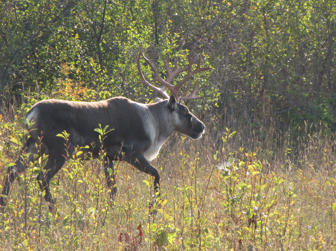 Woodland caribou on Michipicoten Island in Lake Superior. Credit: Christian Schroeder. In May 2018, woodland caribou (Rangifer tarandus caribou) were declared functionally extinct in the United States. The last remnant population in the Selkirks Mountains of Idaho dwindled to three lone females. In the Lake Superior basin, a genetically distinct population of woodland caribou nearly met the same fate in February 2018. Populations in Quebec, Newfoundland, and Alberta are dwindling as well. Across the Canadian north, woodland caribou have disappeared from roughly half their 19th century range. Is climate change dooming woodland caribou? Or are managers using climate change as an excuse to avoid making difficult policy decisions that could save the caribou but antagonize industry and environmental groups? 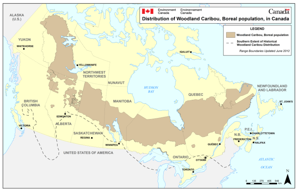 Historic and current range of woodland caribou 2012. The current distribution of boreal caribou is shown in brown. The estimated southern extent of historical woodland caribou distribution is indicated by the dashed line. Credit: Environment Canada. Woodland caribou are part of the globally-distributed species Rangifer tarandus, which includes reindeer in Eurasia, barren ground caribou across the North American Arctic, and woodland caribou in the boreal subarctic. Members of the Cervidae genus, which includes deer, elk, and moose, caribou thrive in a variety of habitats. They are a migratory species that can cover vast distances—or adapt to much shorter migrations. Barren ground caribou and Eurasian reindeer are famous for migrations covering more than a thousand kilometers, while Lake Superior woodland caribou have shorter movements from wintering to calving ranges. One of the few large megafauna species to expand rather than go extinct in the Late Pleistocene, caribou survived repeated glaciations by moving to ice-free refugia. Boreal woodland caribou found refuge in the Appalachian mountains, while Eurasian reindeer moved to what’s now Italy, France, and Spain. Each time the ice retreated in an interglacial period, caribou followed the melting ice north, expanding into new habitats across a diverse, warming landscape.  Global range of caribou and reindeer. Credit: Donna Naughton, Cephas: The Natural History of Canadian Mammals (Toronto: U. of Toronto Press). CC BY-SA 4.0. At least 10,000 years ago, people began following caribou on their journeys north, and a striking diversity of human-caribou relationships developed across the north. In Siberia and Mongolia, Indigenous peoples fully domesticated reindeer, creating close spiritual and material relationships with them. In Sápmi (northern Finland, Sweden, and Norway), the Sami people continued to hunt rather than domesticate reindeer well into the 16th century AD (Langston, 2014). But when Europeans colonized Sápmi for mineral, forest, and agricultural resources, wild reindeer populations declined as the Sami and Europeans began hunting them past their ability to reproduce. The Sami developed a semi-domesticated relationship with reindeer to protect their remaining populations, shepherding them on their long migrations but never fully taming them as beasts of burden. By contrast, North American caribou remain wild, and Indigenous peoples have not domesticated or tamed them. Yet the two species, humans and caribou, have developed extraordinarily close material and spiritual relationships across North America. For example, Gwich’in leader Sarah James said, “The Gwich’in are caribou people” who believe that “a bit of human heart is in every caribou, and that a bit of caribou is in every person.” (Gwich’in Steering Committee, 2005) According to anthropologist Piers Vitebsky, caribou have made human life across the Arctic possible as climates changed in the Late Pleistocene, allowing people to thrive in ecosystems that would otherwise have been uninhabitable (Vitebsky 2005). In the Lake Superior basin, a genetically distinct population of woodland caribou developed, ranging as far south as the Lower Peninsula of Michigan and as far north to Hudson’s Bay in Canada (see Map 1 above). Never particularly abundant in any place other than wolf-free islands—for low caribou numbers helped keep wolf populations low—woodland caribou were widespread across the northern forest. They flee from predators or find refugia in deep snow, windswept barrens, dense bogs, or rocky coastlines, where wolves falter. Predator avoidance was a strategy that served woodland caribou well in North America for over a million years, but now they are vulnerable to predation if their migration routes are cut off by development, or if predator populations increase with human disturbance. And many forms of human activity do increase predation. Railroads, logging roads, forest conversions, and wetland drainage have offered easy access for human and canid predators. White tailed deer have expanded their range into caribou territory, for the edge habitat left by forestry serves them well. Deer in turn invite higher wolf populations, while also spreading a parasitic brain worm that kills caribou but not deer. In 1850, the last woodland caribou vanished from Wisconsin. By 1912, caribou were gone from mainland Michigan. By 1928, the woodland caribou of Isle Royale in Lake Superior were extirpated (Dybas 2015). Minnesota caribou persisted for longer because vast bog and fen complexes provided refuges from hunting pressure and wolf predation. Wildlife managers tried hard to protect caribou in Minnesota, establishing the Red Lake game reserve in the early 1930s and resettling failed homesteaders and blocking their drainage ditches to restore bog habitat (G. D. Racey and Armstrong 2000). Still, by 1937 the last native band of woodland caribou in the bog area had dwindled to three cows in the Big Bog muskeg between Red Lake and Lake of the Woods. Farming and hydropower development along the Rainy River sliced off their traditional migration route between their calving grounds in Ontario and wintering habitat in Minnesota. Biologists translocated caribou from Saskatchewan to the Minnesota population starting in 1938, but without a connection to the Canadian calving ground, the population could not sustain itself (Bergerud and Mercer 1989; Manweiler 1938, 1941). Two individuals straggled down Minnesota’s rocky coastline near the Canadian border during the winter of 1980-1981. One was probably hit by a car and the other's fate is unknown. 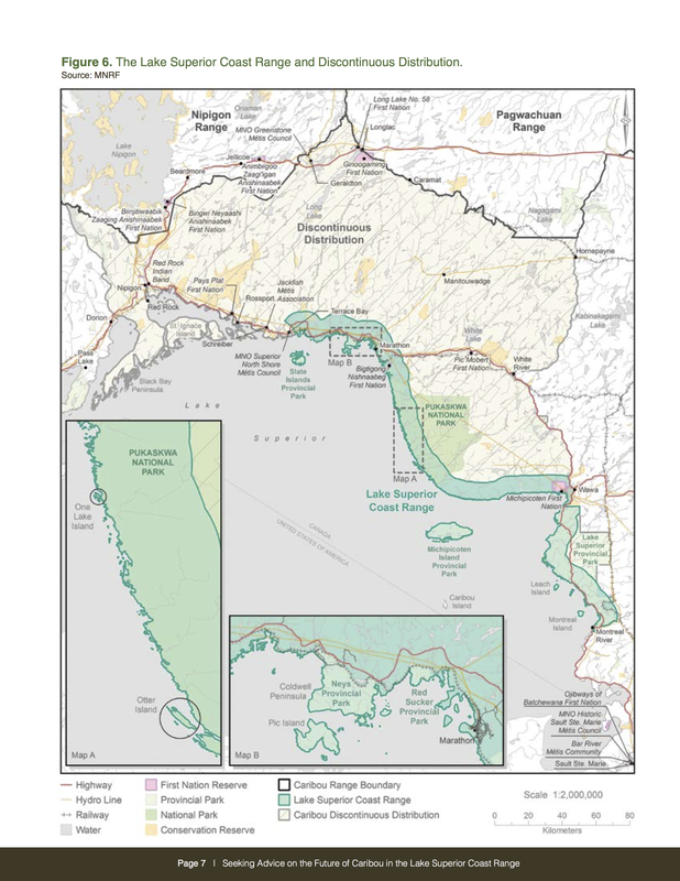 Recent range of Lake Superior woodland caribou. Currently, only small populations persit on Michipicoten Island southwest of Wawa Ontario and the Slate Islands sound of Terrace Bay. Note the discontinuous range between the Lake Superior population and the more northern populations. Credit: Ontario Ministry of Natural Resources and Forestry. In the United States, woodland caribou are now a ghost species persisting only in place names and memories. Ontario’s population of woodland caribou have fared better, yet they too have retreated from most of Lake Superior. From 1880 to 1990, the “extinction of caribou crept northward at a rate of 34 kilometers per decade,” (Badiou and et al., 2011). By 1912, the Lake Superior woodland caribou had been hunted out from the western shore and Thunder Bay region. In the Lake Nipigon watershed just north of Lake Superior, caribou thrived until the Canadian National Railway came through in 1910, and then that population dwindled. Along the north central and north eastern shores of Lake Superior, woodland caribou range had remained continuous all the way north to Hudson’s Bay. But after World War II, mineral, forest, and energy development fragmented their range, and caribou populations became discontinuous, with the Lake Superior population cut off from the more northern populations. This wasn’t a northwards migration, with caribou expanding into new territory. Rather, it was a cascade of local extinctions driven by hunting, predation, and habitat loss. Well into the 2000s, Lake Superior woodland caribou seemed to be hanging on. Populations persisted in Pukaskwa National Park and on refugia in the Slate Islands and Michipicoten Island. When wolves were absent, woodland caribou populations were able to increase exponentially. In the early 1980s, Gord Eason and other biologists translocated 9 caribou from the overpopulated Slate Islands to then wolf-free Michipicoten Island, and by 2012, the population had grown to nearly 1000 individuals. On the much smaller Slate Islands, free from predators, caribou populations may have risen to as many as 600 individuals. Wolves crossed ice bridges in the cold winter of 2013-2014, making their way onto the last two island refugia—Michipicoten Island 16 km off the coast, near Wawa Canada, and the Slate Islands group, about 12 km off the coast near Terrace Bay. Within two years, the population of perhaps 1600 caribou crashed to a couple dozen individuals on Michipicoten Island and several lone males on the Slates. In January 2018, biologists calculated that the entire Lake Superior woodland caribou population might have, at best, two more weeks left on earth before it went extinction. Soon after wolves appeared on the islands in 2014, an informal coalition of the Michipicoten First Nations Community, local cottagers, and caribou biologists had begun petitioning the Ministry to protect the Lake Superior caribou from extinction. Options included culling the island wolves (unpopular with environmentalists) or moving wolves to Isle Royale in Michigan, where the US National Park service had been spending years trying to decide whether to restore them. Alternatively, if wolf control was impossible, then caribou could once again be translocated to wolf-free islands. The Ministry, however, refused to act. In public, their biologists insisted that watching predation play out would be an interesting scientific experiment. Let natural processes find an equilibrium, one Ministry biologist suggested. In private memos that the caribou advocates obtained through Freedom of Information Requests, ministry personnel suggested that they expected extinction and were unwilling to expend resources to prevent it. 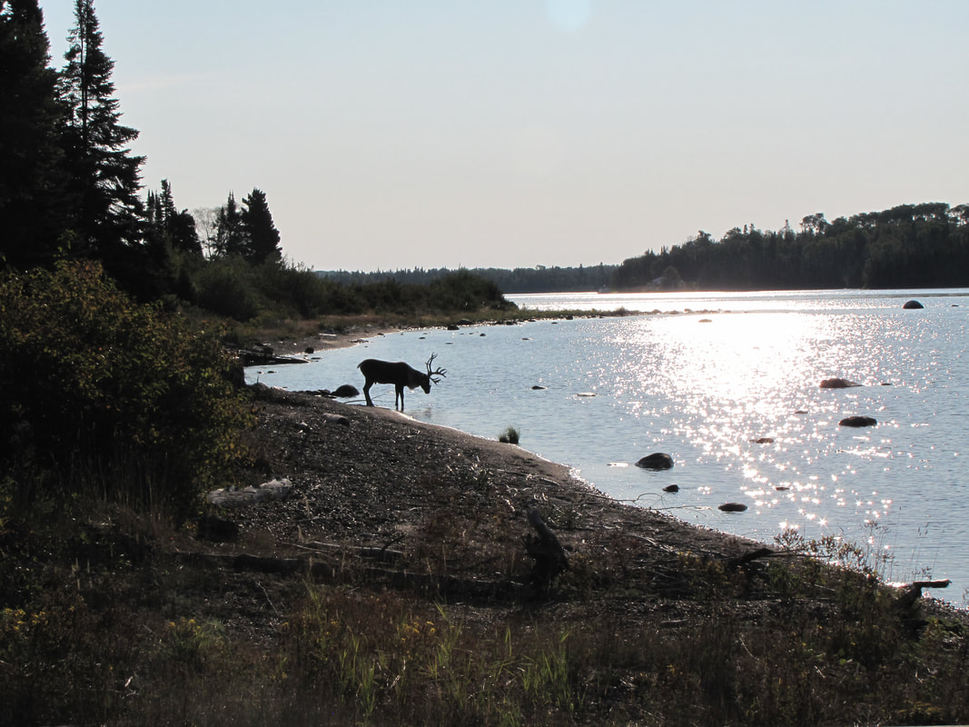 Caribou on Michipicoten Island taken in Quebec Harbor. Credit: Christian Schroeder. After an international media campaign that caught the attention of the New York Times, the Globe and Mail, and numerous regional media sources, the Ministry finally agreed to act. In three dramatic interventions, biologists captured caribou in large nets and helicoptered them over to wolf-free islands. Several were taken back to the Slates archipelago, where wolves had vanished after eating most of the caribou, and others to Caribou Island 35 km south of Michipicoten Island. So far, most of the caribou seemed to have survived the translocations. Calf tracks were found on a beach on the Slates this summer. Perhaps the population won’t face extinction just yet; perhaps woodland caribou won’t completely be extirpated from the Great Lakes region. Why was the Ministry so slow to respond? Local resident Christian Schroeder, an advocate for translocation, suspected that many biologists and policymakers within the Ministry share a perception with environmental NGOs that climate change will inevitably doom the caribou. “Caribou in Canada may be doomed by climate change and habitat loss” proclaimed one headline in Nature World News on Dec. 16, 2013 (Foley 2013). A scientific paper in Rangifer projected “complete loss of woodland caribou in Ontario if winter temperatures increase by more than 5.6º C by 2070,”(Masood et al. 2017). If caribou really are doomed by warming in the Anthropocene, expending significant resources to save them might seem a waste of money and effort. Leo Lepiano, lands and resources consultation coordinator for the Michipicoten First Nation, notes that if the caribou vanish, many management dilemmas for the Ministry vanish as well. Currently, development in woodland caribou range cannot exceed 35% of the landscape. That limit would be lifted for the so-called “discontinuous range” between Lake Superior and the northern populations in if Lake Superior caribou died. More of the boreal forest could be opened to transmission line development, intensive forestry, and Ring of Fire mining expansion. If woodland caribou really are doomed by climate change, why expend resources and slow development save the last few? In fact, caribou, given half a chance, may be far less vulnerable to climate change than other northern species. Physiologically, unlike moose that cannot forage well as temperatures warm, woodland caribou don’t experience thermal stress—at least not in the range of temperatures predicted for Lake Superior. Moose begin to experience thermal stress at 14ºC, with open-mouthed panting and reduced foraging. Caribou, however, don’t show measurable physiological responses until temperatures skyrocket to 35ºC (Racey 2005, Yousef and Luick 1975). Popular perception holds that wintering woodland caribou require old growth boreal forest with abundant lichens. Such forest types are unlikely to persist along much of Lake Superior in a warming climate. But while caribou select lichens in winter if they’re available, they readily adapt to other habitats as well. Michipicoten Island, for example, has a Laurentian mixed forest dominated by hardwoods, and caribou thrive there in the absence of wolves. Caribou responses to historical climate change offer clues to how caribou might respond now. At the end of the last glacial maximum, the fossil record shows that caribou vanished from their warming refugia. Some anthropologists interpret this climate history as evidence of the profound vulnerability of caribou to future climate change (Grayson and Delpech 2005). But this interpretation reduces the agency of caribou themselves. Post-glacial caribou didn’t simply go extinct (as they later did in the 20th century Lake Superior range reductions). Rather, caribou chased the melting ice north, exploring new environments that were opening up as the climate warmed and expanding their range across the circumpolar north. North American caribou populations actually expanded in size at the end of the Pleistocene, as other Pleistocene megafauna (with the exception of brown bear and tundra muskox) went extinct. Migration was central to caribou post-Pleistocene resiliency, suggesting that they can be resilient if their habitats are connected (Mann et al. 2015). Americans typically imagine caribou as creatures of distant wilderness, a remnant of primeval nature that was irrevocably lost to industrialization. Woodland caribou, in this discourse, need vast, untouched wilderness and will be doomed by climate change and the Anthropocene. These beliefs are powerful, but they are flawed—and they let agencies avoid taking pragmatic actions today to restore woodland caribou. There’s nothing inevitable or mysterious about the demise of woodland caribou. Specific policy decisions led to their declines in the 20th century, and reversing those policy decisions has the potential to lead to their rebound, but not if we continue imagining woodland caribou as creatures of an untouched primeval forest. Current rhetoric about woodland caribou mirrors the rhetoric of early conservationists in the late 19th century. As Teddy Roosevelt wrote in 1902, “it would seem the race must become extinct in a comparatively brief period” (pg. 39). When agencies and NGOs talk about woodland caribou as too vulnerable to be sustained in the Anthropocene, it becomes a self-fulfilling prophecy. Agencies and environmental groups become reluctant to restore them, for that suggests continuing care, a need to keep investing time, resources, and energy to manage predators and migration routes. For woodland caribou to thrive, we need to rethink assumptions about the need for continuing human stewardship of migratory wildlife in a warming world. Caribou will indeed dwindle in a warming world if we restrict their migrations and refuse to manage their predators. But climate change should not be an excuse to give up on the management strategies here and now that could keep them from extinction. Climate change isn’t going to doom woodland caribou. Human policy decisions, however, might. Nancy Langston is Distinguished Professor of Environmental History at Michigan Technological University. Her most recent book is Sustaining Lake Superior: An Extraordinary Lake in a Changing World (Yale 2017). She is currently working on an environmental history of woodland caribou and common loons in the Anthropocene. Works Cited:
Badiou, Pascal, and et al. 2011. “Keeping Woodland Caribou in the Boreal Forest: Big Challenge, Immense Opportunity.” International Boreal Conservation Panel. Bergerud, A. T., and W. E. Mercer. 1989. “Caribou Introductions in Eastern North America.” Wildlife Society Bulletin (1973-2006) 17 (2): 111–20. Dybas, Cheryl Lyn. 2015. “Last of the Gray Ghosts: Uncovering the Secret Lives of Our Woodland Caribou.” Lake Superior Magazine. October 1, 2015. http://www.lakesuperior.com/api/content/abae85ae-16cd-11e6-ad59-22000b078648/. Foley, James. 2013. “Caribou in Canada May Be Doomed by Climate Change and Habitat Loss.” Nature World News, December 16, 2013. https://www.natureworldnews.com/articles/5322/20131216/caribou-canada-doomed-climate-change-habitat-loss.htm. Grayson, Donald K. and Franciouse Delpech. 2005. “Pleistocene Reindeer and Global Warming.” Conservation Biology 19 (2): 6. Gwich’in Steering Committee. 2005. “A Moral Choice for the United States: The Human Rights Implications for the Gwich’in of Drilling in the Arctice National Wildlife Refuge.” Langston, Nancy. 2016. “Mining the Boreal North.” American Scientist, June. https://www.americanscientist.org/article/mining-the-boreal-north. Mann, Daniel H., Pamela Groves, Richard E. Reanier, Benjamin V. Gaglioti, Michael L. Kunz, and Beth Shapiro. 2015. “Life and Extinction of Megafauna in the Ice-Age Arctic.” Proceedings of the National Academy of Sciences 112 (46): 14301–6. https://doi.org/10.1073/pnas.1516573112. Manweiler, J. 1938. “Wildlife Management in Minnesota’s ‘Big Bog.’” The Minnesota Conservationist, 14–15. ———. 1941. “Minnesota’s Woodland Caribou.” The Conservation Volunteer 1 (4): 34–40. Masood, Sara, Thomas M. Van Zuiden, Arthur R. Rodgers, and Sapna Sharma. 2017. “An Uncertain Future for Woodland Caribou (Rangifer Tarandus Caribou): The Impact of Climate Change on Winter Distribution in Ontario.” Rangifer 37 (1): 11–30. https://doi.org/10.7557/2.37.1.4103. Racey, G. D., and T. Armstrong. 2000. “Woodland Caribou Range Occupancy in Northwestern Ontario: Past and Present.” Rangifer 20 (5): 173–84. https://doi.org/10.7557/2.20.5.1643. Racey, Gerald D. 2005. “Climate Change and Woodland Caribou in Northwestern Ontario: A Risk Analysis.” Rangifer 25 (4): 123–36. https://doi.org/10.7557/2.25.4.1777. Roosevelt, Theodore. 1902. The Deer Family,. New York: Macmillan and Co., Ltd. Vitebsky, Piers. 2005. The Reindeer People: Living with Animals and Spirits in Siberia. 1st Edition edition. Boston: Houghton Mifflin Harcourt. Yukon Beringia Interpretative Center http://www.beringia.com/exhibit/ice-age-animals/caribou) Ecological Militarism: The Unusual History of the Military’s Relationship with Climate Change5/25/2018
Adeene Denton, Brown University 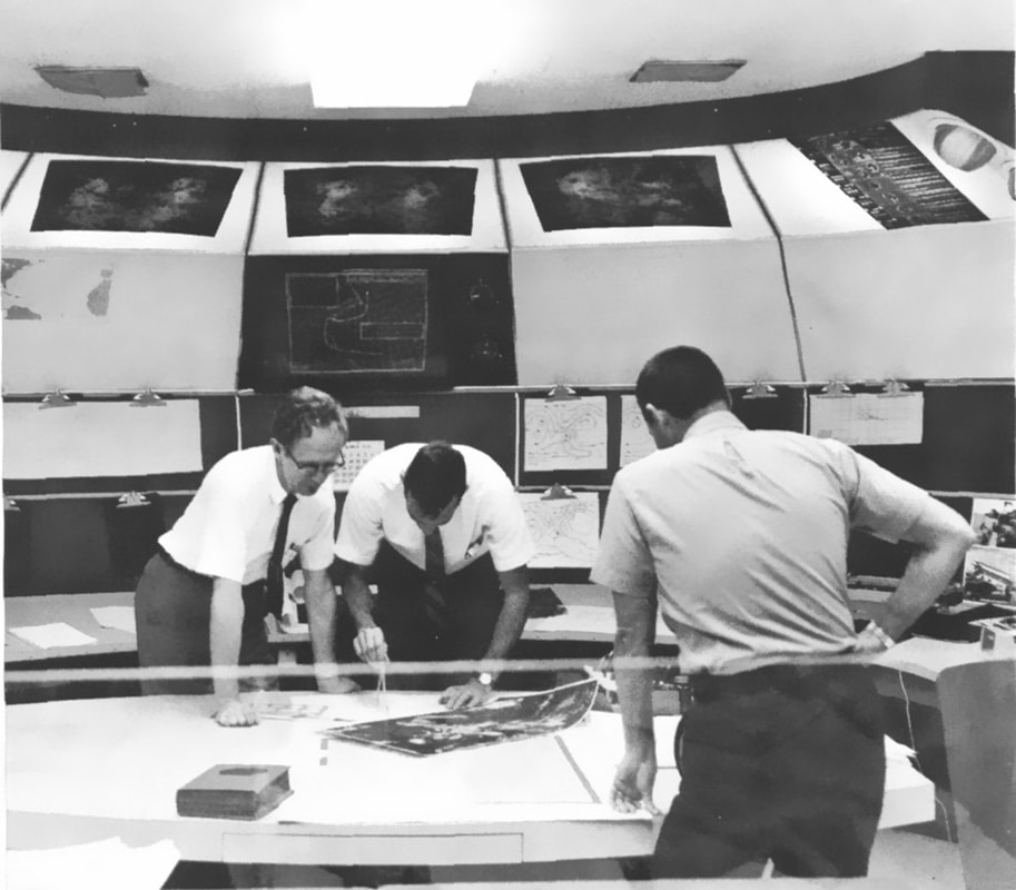 A view of the National Hurricane Center in its early years. Many historians have discussed the influence of the Cold War on the development of specific disciplines within the broader field of earth science. However, few have touched on U.S. military’s study of and attempt to capitalize on climate change, an interest that accelerated rapidly during the Cold War. The decades-long studies sponsored by the Departments of Defense and Energy during and after the Cold War produced a wide array of attempts to transform the earth itself into a political and environmental weapon. The concept of anthropogenic climate change (also known as global warming) captured the world’s attention when James Hansen and other scientists testified before Congress in a series of hearings between 1986 and 1988. However, it had for decades been a subject of debate in smaller scientific, political, and corporate communities. Throughout the Cold War, American political and military leaders considered the potential of specifically directed, human-engineered climate change. They believed that cloud seeding and the atomic bomb, among other tools, would allow them to wield the geological force necessary to control Earth’s climate. Anthropogenic climate change was therefore a concept that excited many U.S. military planners during the early Cold War. Yet these planners, and the scientists and politicians who supported their efforts, struggled with the colossal scale of their desires. They yearned to use human technology to shape the Earth to their political will, but found themselves stymied by the very technologies and politics they sought to control. When the Earth Became Global For a science that is built on the concept of change over inconceivably long timescales, earth science developed at a breakneck pace during the Cold War. As earth science grew both in numbers of people working under its banner and the amount of data they had at their disposal, the field subdivided rapidly (in a case of science imitating life). The 1950s saw a fascinating dual development within earth science: scientists were increasingly recruited to work with and for their national militaries, even as they developed datasets and connections with other scientists that were global in nature. Scientists who wanted to study the history of the earth were looking for datasets that spanned the world, not just their country’s borders. They could only compile them through extensive collaboration with other nations, on the one hand, or, on the other, the vast quantities of funding and manpower that only a major military could offer. Oceanographers chose the latter option as their best chance for technological exploration of the oceans. U.S. naval vessels became the hosts of scientific research cruises, as they had the greatest mobility and most advanced technology of any ships in the world. Many scientists collecting these data were loath to discuss the tensions between their research and any political agendas, but it was certainly on their minds – and on the minds of their benefactors. For the Navy and the other branches of the U.S. military, scientific projects typically served multiple purposes. The data collected provided both a research boost to a specific scientific community, and information that the military might be able to use. Radio arrays in the Caribbean, for example, which were ostensibly used for ocean floor sounding and bathymetric mapping, also scoured the sea for Soviet submarines. Overall, the military hoarded big data about the earth and its climate for use in future tactical and strategic plans. Climate and environmental science became yet another venue in which the Cold War was fought. Yet the relationship between climate science and the political interests that funded it was an uneasy one. When researchers in conversation with the military realized that humanity was becoming a force that could act on a geologic scale, the possibility of extending U.S. control to the environment became extremely appealing to military planners. As American oceanic scientists saw the bathymetry of the seafloor for the first time, the political and military forces in Washington were haggling over just how much ocean the U.S. could control outside its borders. American oil companies like Chevron and Mobil became technological giants over the course of the Cold War by expanding their search for petroleum to South America and Africa, and their profits seemed to suggest that the earth’s interior was also within the scope of human knowledge and jurisdiction. After 1957, the dawn of the space age seemed to herald the beginning of total surveillance from above, and for the military planetary surveillance was the beginning of integrated planetary control. The more scientists discovered about the earth on which they lived, the more their military partners sought to use that information to bring the earth to heel. All of these ideas seemed to coalesce together during the Cold War, yielding decades of oscillating cooperation and struggle between the U.S. military and the scientists it patronized.  Maurice Ewing in 1948. Ewing was one of the many earth scientists who used navy vessels to obtain powerful oceanic datasets. Columbia University. The Military as a Geological Force During the early Cold War, U.S. military planners often proposed schemes to transform environments on immense scales, only to quickly abandon them either in the proposal stage or after initial testing. The initial popularity of such ideas, as well as their typically quick demise, owed much to military ambitions far exceeding capability. Environmental control was an undeniably powerful concept, as it promised ways to turn the tides of war through untraceable methods, or from continents away. Unfortunately, the military’s tactical plans to utilize newfound climate information often took unusual (and unusable) turns because much of the information was very new, and because experts consulted were not always well versed in the information they handled. Climate science was a field in its infancy, and not everyone who claimed to speak on its behalf understood the data. A classic example of this phenomenon was proposal developed by Hungarian-American polymath John von Neumann to spread colorants on the ice sheets of Greenland and the Antarctic. By darkening the ice, the military could reduce their reflectivity, or albedo, which would warm the poles, melt the ice, and ultimately flood the coastlines of hostile nations. It was an absurd idea proposed by a brilliant physicist who did not yet grasp how global the effects of such a plan would be. Melting of the Greenland ice sheet in particular would have drastic impacts on the North American continent as well as the intended target. The U.S. Departments of Energy and Defense, as well as President Eisenhower, were also interested in using humanity’s newfound power for good, however. Operation Plowshare, for example, was the name given to a decades-long series of attempts to use nuclear explosives for peaceful purposes, particularly construction. It resulted in of proposals such as Project Chariot in 1958, which called for the use of five thermonuclear devices to construct a new harbor on the North Slope of Alaska. Scientists were often split in their reactions to these proposals, a conflict provoked by their valuable relationship with the U.S. government, on the one hand, and risk to terrestrial environments they were only beginning to understand, on the other. 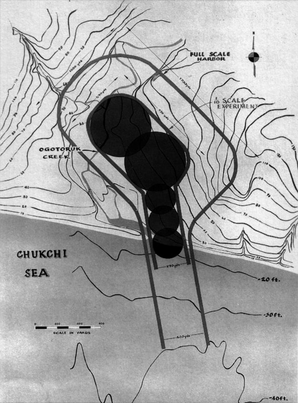 The original Project Chariot design, which would have utilized 2.4 megatons of explosives. Mud, Not Missiles: Weaponizing Weather in Vietnam When the U.S. military started seriously considering the possibility of human-driven climate warfare, its planners focused on a concept that has been human minds for centuries: controlling the weather. Weather modification has preoccupied scientists, politicians, and the military in the U.S. since James Espy, the first “national meteorologist” employed by the military, studied artificially-produced rain in the 1840s. In the early Cold War, such projects continued to intrigue military planners. In 1962, the U.S. military launched Project Stormfury, an attempt by researchers at the Naval Ordinance Test Station (NOTS) to test weather control by seeding the clouds of tropical cyclones. They hoped to weakened hurricanes that regularly wreaked havoc on the southern and eastern coasts of the United States. They theorized that the addition of silver iodide to hurricane clouds would disrupt the inner structure of the hurricanes by freezing supercooled water inside. Yet their cloud seeding flights revealed that the amount of precipitation in hurricanes did not appear to correlate at all with whether a cloud had been seeded or not. In the meantime, however, members of the U.S. high command used the theory behind Stormfury as a basis for two similar operations in Asia: Projects Popeye and Gromet. Despite Project Stormfury’s failure to deliver measurable results, the need for any kind of interference that could harry the Viet Cong led military planners to rush Popeye into the testing phase. The scientists recruited to assist with Popeye slightly modified Stormfury’s cloud seeding approach. They decided to use lead iodide and silver iodide in large, high-altitude, cold clouds, which (in theory) would then “blow up” and “drop large amounts of rain” over an approximately targeted area. If successful, Popeye would increase the rainfall during the monsoon season over northern Vietnam, hampering their forces by destroying their supply lines. This would lengthen the monsoon season, which would force the Vietcong to deal with landslides, washed out roads, and destroyed river crossings. American officials had also promised the Indian government that they could seed clouds to end a crippling drought in India. Cloud seeding, military planners, could both win allies and cripple enemies. Despite the eagerness and ambition with which the U.S. military undertook testing of this method in both India (with government permission) and Laos (without informing the Laotian government), it was ultimately unclear whether these attempts at “rainmaking” were effective at all. The utmost secrecy with which Projects Gromet (in India) and Popeye (in Laos and Vietnam) were undertaken limited attempts to measure and verify their success. Gromet alone cost a minimum of $300,000 (nearly $2 million in present-day US dollars), yet by 1972 U.S. officials had to concede that its effectiveness had been unclear at best. The Indian drought ended, but no one could say whether it was the U.S. that had done the job.  1966 photo of the crew and personnel of Project Stormfury. National Oceanic and Atmospheric Administration. Politics, Military, and Oceans For scientists, the ocean represents a crucial biological and chemical reservoir whose massive size makes any fluctuation of oceanic conditions a crucial aspect of climate change. In the early Cold War, the oceans also became a focus for the development of poorly conceived climate control plans, as well as a site for political posturing. There were two basic prongs to the American (as well as other countries’) political and military approach to the oceans during the Cold War. First, the oceans were seen as a way to extend a country’s sovereign borders, and second, as a mechanism for disposing of unsavory nuclear waste. As American scientists followed the Navy to exceedingly remote places in search of new datasets, the question of nationalism followed them. Where could the Navy “plant the flag” as part of its surveys? Polar scientists who sought direct access to their regions of interest – the Arctic and Antarctic – were hamstrung by the security interests of not just their own nations, but also of others. The U.S. government, which noted the conveniently large strip of polar access given by USSR’s ~7,000 km of Arctic coastline, pushed to extend its sovereignty as far off of Alaska’s northern continental shelf as it could. Where scientists saw the Arctic as a fascinating environment and ecosystem, the U.S. military saw a direct route to its biggest enemy. In Antarctica, meanwhile, by the International Geophysical Year (1957-1958) over seven different countries had laid claim to large swaths of the frozen continent. The British had already secretly built a base on Antarctic Peninsula during World War II to supersede other claims to the area. Establishing the Antarctic continent as a zone that was to be as free from geopolitics as possible (as well as exploitative capitalist interests) was a difficult task, and one that took decades. It took until the Clinton administration for oil companies to be officially banned from prospecting on or near the continent, essentially reserving Antarctica as a place where only collaborative science could reign. As the U.S. and other major powers jockeyed with each other for territory in the most remote areas of the world, they also used the ocean as a garbage disposal for some of humanity’s most toxic waste. Between 1946 and 1962, the United States dumped some 86,000 containers of radioactive waste into the oceans, while Britain, the USSR, and other developing nuclear powers did much the same. Meanwhile, scientists from the International Scientific Committee on Ocean Research started collecting data on the possible dangers associated with radioactive waste. However, governments funding their research had little interest in the results until U.S. waste washed back up onto American shores where local fishermen found and identified it. For years, the ocean was convenient to U.S. officials. Its volume seemed limitless: perfect for permanently keeping radioactive waste, and any information about it, from the public eye. Fortunately, oceanic waste dumping did not stay a secret forever. There was, it seemed, no convenient way to dispose of radioactive waste. Dumping it on land provoked public criticism at home, and dumping it in the oceans invited international criticism, particularly from the Soviet Union, whose government claimed to have never done such a thing. In fact, it did; the USSR sank eighteen nuclear reactors in addition to packaged waste, a fact only revealed in declassified archives after the Soviet Union collapsed. To describe the relationship between the U.S. government and the oceans during the Cold War as fraught would be an understatement. The Navy wanted the ocean to be an effective source of information on Soviet activities, a convenient landfill, and a platform to extend American political authority. In the end, the Navy could not have it all. By the end of the Cold War, the Navy and its political supporters had to concede to public and scientific pressure to back away from large-scale projects that overtly exploited the ocean. The power jockeying and technological exploitation during the Cold War did have lasting effects, however. Today, the oceans remain a site of intense monitoring and political grandstanding. 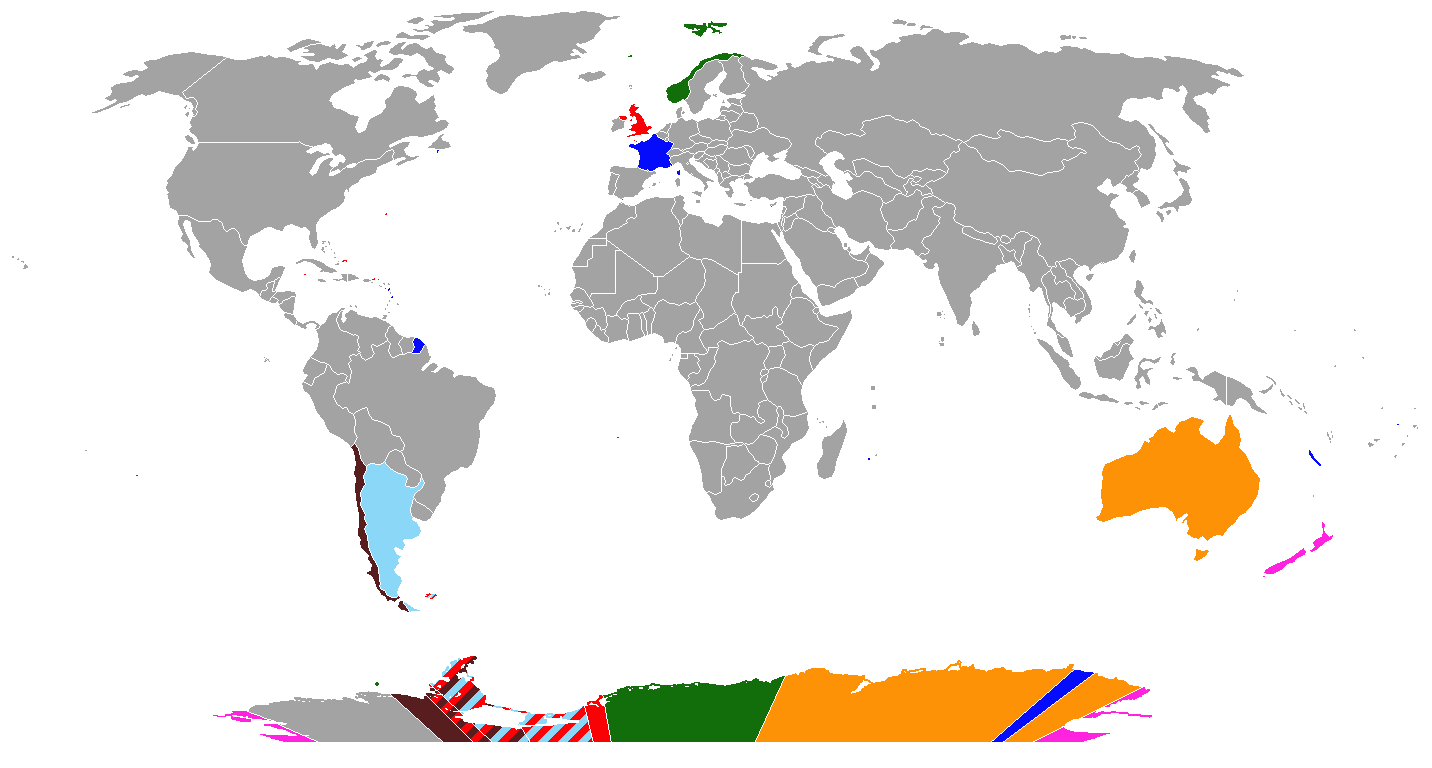 A comparison of the seven land grabs made by countries in Antarctica. The U.S. and U.S.S.R. did not stake any specific claims. Image from Nature Geoscience. The Cold War and the Warm Future In his speech to the National Academy of Sciences in 1963, President Kennedy noted that human science could now “irrevocably alter our physical and biological environment on a global scale.” This was a fundamental realization – that humans could change the world, and they could do it in a matter of minutes to years if they chose. The Cold War forced scientists and their military benefactors to realize that humans had become more efficient at shaping the Earth than most geological forces in existence. It was tempting, then, for Cold War militaries to investigate just how far that power could go, in both destructive and constructive ways. Can we lengthen or shorten the seasons? The military tried it. Can we disappear our worst waste in the oceans? Every country with nuclear waste tried it. How much do we need to know about the environment before we can begin to reshape whole regions to suit nationalistic goals and objectives? For the military during the Cold War, the answer was almost always “we know enough.” For some of the scientists they employed, and many more whom they didn’t, the answer was “we may never know enough.” Popular discussions rarely touch on the outlandish attempts to control nature during the early Cold War. In our present age of polarization around the issue of climate change, perhaps they should. Politicians and scientists too often assume that humanity will someday engineer a solution to climate change, but the Cold War’s history reveals that our grandest schemes may be the most susceptible to failure. Selected References Doel, R.E. and K.C. Harper (2006). “Prometheus Unleashed: Science as a Diplomatic Weapon in the Lyndon B. Johnson Administration.” Osiris 21, 66-85.
Fleming, J.R. Fixing the Sky: The Checkered History of Weather and Climate Control. Columbia University Press: New York City. 2010. Hamblin, J.D. (2002). “Environmental Diplomacy in the Cold War: The Disposal of Radioactive Waste at Sea during the 1960s.” The International History Review 24 (2), 348-375. Marzec, R.P. Militarizing the Environment: Climate Change and the Security State. University of Minnesota Press: Minneapolis. 2015. Naylor, S., Siegert, M., Dean, K., and S. Turchetti (2008). “Science, geopolitics and the governance of Antarctica.” Nature Geoscience 1. O’Neill, Dan (1989). “Project Chariot: How Alaska escaped nuclear excavation.” Bulletin of the Atomic Scientists. 45 (10). “Text of Kennedy’s Address to Academy of Sciences,” New York Times, Oct 23, 1963, 24.
Dr. Dagomar Degroot, Georgetown University
The Tipping Points map at the time of publication (April 30th, 2018).
In late 2016, Randall Bass, vice provost for education at Georgetown University, asked me to help design and teach a pilot project at Georgetown University that would experiment with a new way of introducing climate change to undergraduate students. The Core Pathway on Climate Change initiative, as we came to call it, ultimately allowed students to mix and match seven-week courses - "modules" - to find their own pathway through the scholarship of climate change. Each module explored climate change from a different disciplinary vantage point, from English Literature through Environmental History and the Earth Sciences.
Students could, for example, mix modules on literature and climate change with modules on the theology and philosophy of climate change. Alternatively, they could select modules on the physics and chemistry of climate change with environmental science modules that survey the impacts of global warming on water use and the ecology of cities. We scheduled every module for the same time, and we capped each at around 20 students. The program attracted over 100 students, many of whom were eager to learn more about climate change and anxious to be part of solving its pressing challenges. After and in some cases during every module, all the students in the program convened for "integrative days" in large halls or auditoriums. Often, we would guide students through an activity that encouraged them to draw on the distinct disciplinary insights they had learned in their modules. In our final integrative day, former Vice President Al Gore joined us for a series of meetings and talks that addressed the gravity of the climate change crisis and the prospects for overcoming it. 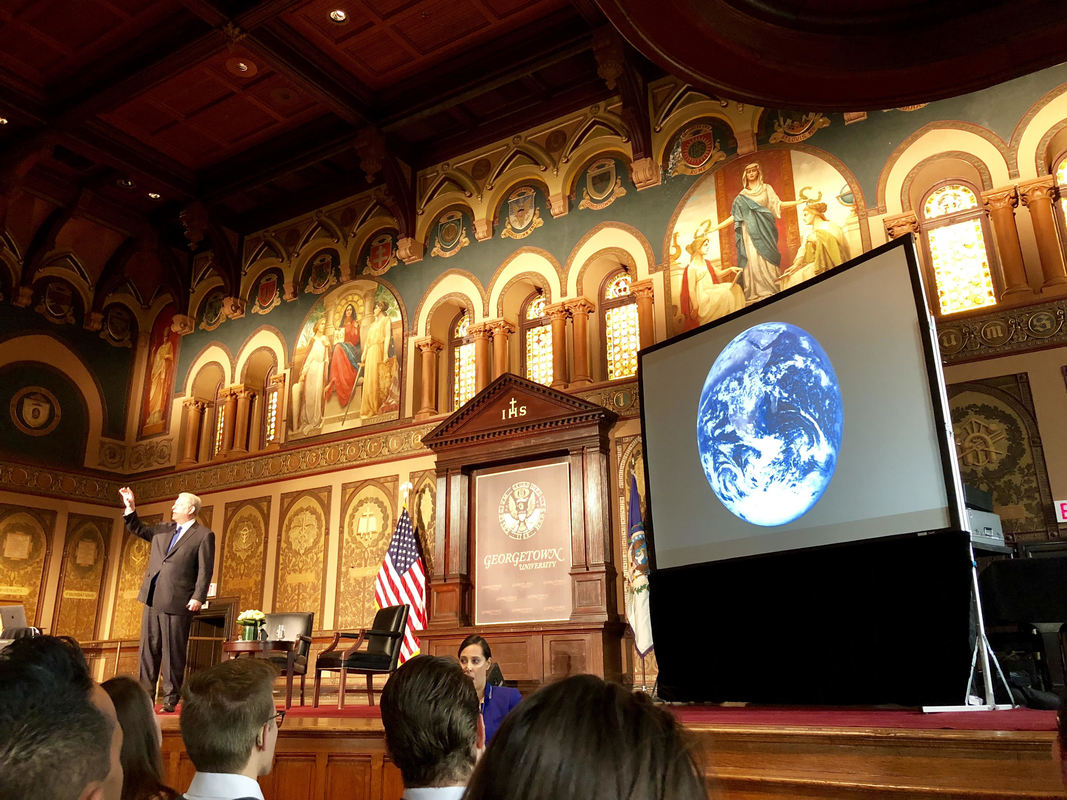
Al Gore gives his final talk at the last integrative day of the Core Pathways Program at Georgetown University.
I taught two environmental history modules in the Core Pathway on Climate Change: one that surveyed how societies coped with the climatic cooling of the Little Ice Age from the thirteenth through the nineteenth centuries, and another that explored the causes, consequences, and controversies of anthropogenic global warming. Both modules cover huge topics, of course, but the seven-week format actually helped me emphasize what was most important about them.
Students in my Little Ice Age module learned how scholars work together to reconstruct past climate changes, studied what the history of natural climatic variability tells us about the causes of climate change, and evaluated what made societies vulnerable - or resilient - in the face of climatic cooling. Students in my global warming module learned about the "discovery" of global warming; weighed scholarship about its environmental and human consequences; traced the history of "geoengineering" schemes, and debated the causes for government inaction. The innovative design of the Core Pathways Program and the quality of our students also encouraged me to experiment with different kinds of assignments. Early in 2017, I won a Georgetown Environment Initiative grant for a new initiative - the "Tipping Points Project" - that aims to raise popular awareness about the consequences of global climatic trends for local communities. My grant covers events at Georgetown that connect climate scholars who actively reach out to the public, but from the start I imagined that the heart of the Tipping Points Project would be a map littered with icons that directed visitors to short, jargon-free articles on the impacts of climate change in local communities. The focus would be on the United States: still the world's superpower, and the only country poised to withdraw from the Paris Agreement on Climate Change. As I prepared to teach my first Core Pathways modules, I realized that some of my assignments could require my students to write first drafts of these articles. With that in mind, I created a first edition of the Tipping Points map and website. I added a page to the website that listed online tools that visitors and students could easily use to reconstruct and project climatic trends - temperature, precipitation, sea levels, and more - in local communities. To see if students could actually use these tools to write compelling articles - and to give them templates for those articles - I drafted two short pieces for the website. The first examined how climate change would likely impact the environments and people of Washington, DC, while the second explored the impacts of past climate change in Tulare County, California. 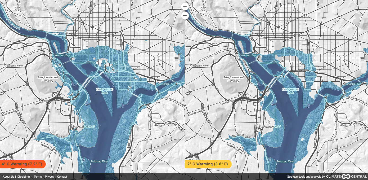
Many students gravitated towards the the Climate Central "Surging Seas, Mapping Choices" program, which represents the impacts of rising sea levels on coastal communities, in different emissions scenarios (and absent adaptive responses).
Students drew on these templates to write their own Tipping Points articles. In our Little Ice Age module, they used the tools on the Tipping Points website to reconstruct the impacts of past climate change in local communities, while in our Global Warming module, they used other tools to project the consequences of climate change, sometimes in the same communities. Often, they chose to write about counties and cities that had special significance for them: hometowns, places they visited, places they aspired to live in. Sometimes, they wrote for family members they hoped to persuade.
I stressed that every article should follow a simple format. It had to have three parts devoted to, first, the impacts of climate change on local environments; second, how we know that those impacts had happened or would likely happen; and third, the likely consequences of those environmental impacts for local communities. I challenged students to avoid jargon while clearly explaining the mechanisms behind the relationships they uncovered. It was not enough for them to mention, for example, that global warming would likely make severe hurricanes more common. They had to explain how warmer waters, changing atmospheric circulation, and rising sea levels would likely all play a role in intensifying the worst hurricanes and magnifying their human impacts. Perhaps above all, students learned just how difficult - but how important - it can be to communicate complex ideas in plain English. In the end, my students submitted roughly seventy Tipping Points articles in my modules. As I painstakingly edited and expanded each article, I decided that the icons on our map should convey something about the articles to which they linked. First, I opted to color-code the icons: blue for articles that dealt with past climate change, and red for articles that projected future climate change. I figured out a way to allow visitors to view only articles about past or present climate change, if they played with the filters on our map. Second, I decided to use icons that visualize the major weather trends in each article. A thermometer represents temperatures changes; waves represent rising sea levels; cyclones represent hurricanes; rain drops represent liquid precipitation; and suns represent droughts (okay, that one is a little less straightforward). As I populated the Tipping Points map with icons, I was struck by how clearly it visualized the extent to which climate change had already altered environments and impacts communities across the United States. Droughts already routinely stretch across the southwest; hurricanes and rising sea levels already imperil the east coast. And of course, there is so much more to come. The Tipping Points map currently features icons that link to nearly twenty student-written, and professor-revised, articles. Each include striking visualizations, many created by students using the accessible tools listed on our website. By the end of the summer, the map should be teeming with as many as seventy icons. Bathsheba Demuth - our assistant director at HistoricalClimatology.com and the Climate History Network - may also ask her students at Brown University to write Tipping Points articles. That would allow us to host over 100 articles by spring 2019. Going forwards, we will use our online resources - including our social media feeds - to direct visitors to new articles as they come online. We will permanently link to the Tipping Points project under the "resources" tab of HistoricalClimatology.com. Ultimately, I hope that the Tipping Points map will provide a first stop for ordinary people interested in the impact of climate change in their communities. It may also serve as an example of the ways in which instructors can use simple, digital platforms to allow undergraduate students to create resources that have both pedagogical value in the classroom, and practical value in the real world. So please, visit the Tipping Points website, and stay tuned for much more! Species Stories: North Atlantic Right Whales From Their Medieval Past To Their Endangered Present3/21/2018
Dr. Vicki Ellen Szabo, Western Carolina University  Entangled right whale, 2010, NOAA News Archive 123110, fish2378, NOAA's Fisheries Collection. 2017 was a calamitous year for the North Atlantic right whale. The final count of the 2017 "Unusual Mortality Event" or UME, as defined by the Marine Mammal Protection Act, was eighteen animals. Fourteen North Atlantic right whales were found dead from the Gulf of Saint Lawrence to Cape Cod between June and December, with an additional four strandings and entanglements through the year. An average annual mortality rate for the North Atlantic right whale is four animals. To make matters worse, these right whales began 2017 with an estimated population of just 450 animals, including only about one hundred breeding females who have exhibited such stress in recent years that their breeding rate has slowed. As proof of this, in addition to the UME, 2017 saw no recorded calf births. The cause of the UME is no mystery; warming waters have expanded the whales' habitat further north. Bypassing their usual feeding grounds in the Gulf of Maine, most of the whales were found entangled or dead in the Gulf of St. Lawrence, where they have sought out their favorite food, Calanus finmarchicus or copepods, a cold water species. Measures in place in more southern waters to prevent entanglements and ship strikes haven't been implemented further north, but as the whales move, so too must these regulations – if there is time left. Marine ecologist Mark Baumgartner of Woods Hole Oceanographic Institution ominously noted in December 2017 that North Atlantic right whales, without immediate intervention and protective measures, would be extinct in twenty years. The story of the North Atlantic right whale may end in 2040, but the beginning of the end of this species may have begun a thousand years earlier. 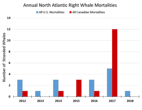 2017-2018 North Atlantic Right Whale Unusual Mortality Event, from NOAA Fisheries Marine Life in Distress. North Atlantic right whales, Eubalaena glacialis, earned their common name because of the ease with which they were hunted – they were literally the 'right' whales to hunt. Right whales are bountiful in blubber, giving them exceptional buoyancy, even after death. Their shallow coastal habitat, slow swimming speed, docility, and sizeable pods - averaging twenty but recorded in superpods of one hundred animals - made them accessible and attractive to coastal predation. Averaging fifteen meters in length and 40 - 100 tons in weight, a single right whale could feed and supply a premodern community for months. The deck is stacked, it would seem, against the Atlantic species, and it is clear that all of these natural factors led to significant premodern exploitation of the right whale across the Atlantic. While a population of right whales also exists in the Pacific, predation or natural causes have not led to a dramatic population decline as we see in the Atlantic. Biologists have estimated around 5500 right whales taken across the North Atlantic from the 17th through the early 20th centuries. Reaching an estimated population low of 100 in the 1930s, the species’ brief recovery to approximately 500 animals in the modern era is cold comfort. Without a sense of a historical baseline or 'natural' population of North Atlantic right whales, both in population size and genetic diversity, it is difficult to estimate what a recovered population should look like and whether recovery is even possible. Historians and marine biologists recognize that human exploitation and interference have had a massive impact on the North Atlantic right whale, particularly during and since the sixteenth century. Randall Reeves says that this species has suffered from “one of the most extensive, prolonged, and thorough campaigns of wildlife exploitation in all of human history.” It is a challenge, though, to determine the full extent of human interference in the case of premodern depletions of extinctions. North Atlantic right whales once existed in two presumed separate breeding populations. Still extant, for now, is the population local to the western North Atlantic and the North American coastline. An eastern North Atlantic population, thought to have bred off the coast of the Canaries and migrated along the Atlantic coast to the Subarctic, is presumed extinct. Of this population, though, we know almost nothing with respect to population size, species duration, or genetic diversity. Did changes in premodern climate – the Medieval Climatic Anomaly and the Little Ice Age – affect the whales' migrations and habitats alongside human interference? Were right whales so heavily predated in premodernity that non-industrial whaling could bring about the end of a population? This is the case typically made for North Atlantic gray whales, extinct by the eighteenth century, and for the eastern population of North Atlantic right whales. Does this also explain the precarious state of the western population of North Atlantic right whales? Reeves, in 2007, wrote that “historical research has provided a general perspective on past right whale distribution, population structure, and numbers, but understanding of just how abundant these animals were when whaling began in the North Atlantic remains vague." In 2008, Brenna McLeod led a genetic analysis of historical North Atlantic right whale remains from whaling stations up and down the Labrador coast. McLeod and her team concluded that “the pre-exploitation population size of right whales was clearly much smaller than previously estimated [which] has effected our modern impressions of the recovery of right whale stocks.” In short, predation almost certainly played a role in the species' decline, but the degree remains unclear. The deep history of North Atlantic right whales and their ill-fated engagements with human populations could offer a valuable lens at this critical moment for the species. Historical and archaeological proxy data on cetacean populations, especially for the North Atlantic right whale, may contribute to analysis of modern species populations, habitats, behaviors, and other statistics. Working back from peak points of exploitation through the earliest records of right whale use, historical and archaeological evidence may provide useful context for this imperiled species. 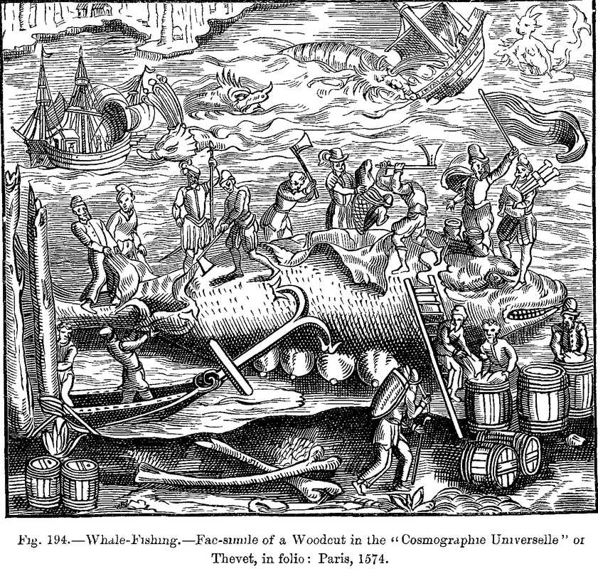 Basque Whale-Fishing. Facsimile of a Woodcut in the "Cosmographie Universelle" of Thevet, in folio: Paris, 1574. Project Gutenberg text 10940. We often begin the story of the North Atlantic right whale extirpation with the medieval Basques, who historically have been blamed for the destruction of the eastern branch of the North Atlantic right whale. The Basques established some of the earliest whale fisheries along the European Atlantic coast, maintaining those fisheries from the 13th through the early 20th centuries. Forty-seven medieval and early modern French and Spanish Basque ports have been identified as possible whale fisheries. Alex Aguilar, using catch data from its beginnings in the 16th century, estimates that each port may have taken one or at most two whales a year through the eighteenth century. Far from the depredations wrought by industrial whaling, even this small catch was enough to make an impact on the population, as the Basques were known to target whale calves, and the Bay of Biscay may have been the winter nursery for the eastern population of the North Atlantic right whales. In some ports, Aguilar concluded that the catch of calves accounted for over 20% of records. Additionally, mothers will follow struck calves, making them more readily subject to predation as well, and removing breeding females from the population. This hunting strategy, common among preindustrial whalers, would explain the apparent downturn in catch records by the 18th century and a thinning population that may have precipitated Basque movements to new hunting grounds in North America and the Northeastern Atlantic and Subarctic, where their quarry was the western population of North Atlantic right whales. Also to be considered are possible changing habitats and migrations over the course of the Little Ice Age, when Bowhead whales may have moved south into the Subarctic, potentially competing with right whales for prey. Basque whalers in Labrador reportedly caught well over 20,000 animals, presumed, again, to be right whales. Archaeological and historical investigations of around twenty whaling ports along the Labrador shore, focusing especially on the major Basque port of Red Bay, have forced a reassessment of the role of the Basques in right whale extirpation. In genetic analysis of nearly three hundred whale bones from ten of those ports, only one sample was identified as right whale. Over two hundred bones came from bowhead whales, of which 72 individual animals were identified. The unanticipated number of bowheads on these sites has altered our perceptions not only of the right whale's decline, but also of the expected habitats of the bowhead. While not clearing the Basques of impact in the decline of the right whales, their involvement may not have been central to this population’s decline. The Basques had another crack, potentially, at the North Atlantic right whales during their ill-fated residence in the Icelandic Westfjords, but they weren’t the only hunters targeting these animal populations.  Sléttbakur (right whale); Handrit Jóns Guðmundssonar lærð, JS 401 XI a 4to, National and University Library of Iceland. Right whales and their utility to human societies has been documented for over a thousand years in Europe. This documentation largely comes from the Northern world, and specifically from Norse populations, from the homeland and across the diaspora. Norse whalers in Ireland, according to a Spanish geographer, spent the 11th century picking off right whale calves, perhaps from the same population travelling through the Bay of Biscay: "… on their coasts, [the Norsemen] hunt the young of the whale, which is an exceeding great fish. They hunt its calves, regarding them as a delicacy. They have mentioned that these calves are born in the month of September, and are hunted in the four months October to January. After this their flesh is hard and no longer good for eating…. Then they cut up the meat of the calf and salt it. Its meat is white like snow, and its skin black as ink." The North Atlantic right whale migration up the European coast peaked in January, but lasted from October through March, according to Aguilar's analysis of the Basque hunt in Spain and southern France. If right whale calves were being taken at multiple points up and down the European coast, the seemingly minimal catch of the Basque ports become magnified in its impact. In addition to the Norse whalers of Ireland, Norsemen back in the homeland itself had already been targeting right whales some three centuries prior. The laconic merchant-hunter Ottar was an Arctic hunter of right whales off the coast of northern Norway, or so he told King Alfred and his court in the ninth century. The whales of Ottar's homeland, he noted, were far bigger than those he fished from the sea off Tromsø, but his ship, along with five others, reportedly killed sixty large whales in the span of two days. Ottar describes the whales as being up to 20 meters long, and while perhaps exaggerated, many historians have surmised that his quarry were right whales, a species called "the first commercial whale." For ninth-century Norsemen, the ability to shoot at and kill whales was second, perhaps, to their capacity to control and acquire. A whale that sank was of no good to anyone, but whales that floated would certainly be keenly sought. Barring any reference to netting, floats, or lines secured by harpoons, a primitive hunter could kill and acquire a right whale if conditions were right. There is good reason to place faith in the ability of hunters like Ottar or the Hiberno-Norsemen to recognize whales they could catch. The twelfth-century anonymous King's Mirror, old Norse Konungs skuggsjá , described the behavior and appearance of over a dozen species of North Atlantic whales. Medieval manuscript illuminations from Scandinavian and Western European texts depict whales in various recognized activities that awe and delight us today - breaching, porpoising, spy-hopping, logging and especially predation. Among the most articulate and observant of all premodern authors was the late medieval Icelander Jón Guðmundsson, also known as Jón Laerði, or Jon the Learned (1574-1658). Jón was a sorcerer and a poet, a physician, outlaw, artist, fisherman, historian, and naturalist. He possessed a wealth of local, traditional environmental knowledge on seafaring, fishing, and especially on whales.  Jón Laerði, or Jon the Learned (1574-1658), illustration of whale species from his Natural History of Iceland, GKS 1639 kvart, Royal Library, Copenhagen; photo courtesy of Icelandic Museum of Natural History. Jón was born and lived in the Snaefellsness peninsula in Western Iceland, where he says he saw many whales. He also lived in the Westfjords, where he witnessed and recorded the infamous killing of Basque whalers in 1615. Sometime before his death, perhaps around 1640, Jón wrote a work called the Natural History of Iceland in which he illustrates and describes twenty-two whale species of Iceland. According to Viðar Hreinsson, recent biographer of Jon Laerði, Jón compiled illustrations with Danish captions of nineteen whale species, in addition to a rather skinny walrus, on a loose leaf of paper preserved in the Royal Archive in Copenhagen. The right whale according to Jón exists in two varieties, one smaller, the sléttbakur and a larger animal which he calls höddunefur, measuring 35 ells at the longest (about 17 meters). The smaller whales are the ones most hunted, particularly for their valuable blubber. Icelandic waters, he notes, had been home to a large number of those whales, but the "foreign whalers have reduced the number of this species the most." One wonders which of the right whales – western or eastern North Atlantic - were being preyed upon and whether the diminished species, which he notes, was the beginning of the end of the North Atlantic right whale. In what ways can past histories tell us something new, critical or important about modern animal populations? In the case of the North Atlantic right whale, new technologies like ancient DNA analysis offer a possible means of insight into the current state of this population and context for the references to the species throughout medieval and early modern literature and history. Through an ongoing National Science Foundation Arctic Social Science project, (NSF # 1503714, Assessing the Distribution and Variability of Marine Mammals through Archaeology, Ancient DNA, and History in the North Atlantic; henceforth Norse North Atlantic Marine Mammal Project or NNAMMP) genetic materials from whale remains found on numerous archaeological sites in the North Atlantic and Subarctic may provide evidence related to modern right whale populations. Archaeological sites across the North Atlantic often preserve fragments of marine mammal bones both as artifacts and as butchery or bone working residue. The Norse North Atlantic Marine Mammal Project has compiled over 200 worked and waste whale bone samples from a dozen archaeological sites in Iceland, Greenland, North America, the Faroes and Orkney, ranging from 800 through 1500 CE. Whale bone is a challenging resource for archaeological analysis, defying typical zooarchaeological standards for data recording and analysis. Whale bone is not transported to archaeological sites as part of animal butchery, so bones that are found on a site do not follow regular butchery patterns. Depending on the size of the animal stranded, only 10 to 15% or less of an animal’s body weight may be derived from hard tissues; in the case of North Atlantic right whales, about 13% of an animal’s body weight is bone. This detail becomes important when you consider that the physical evidence of premodern whale use must come from this small percentage of hard tissues, of which only a fraction – if any at all – is transported from a coastal butchering site to an inland settlement. Complicating matters, medieval laws and charters, in Iceland and across the Continent, scrupulously divide stranded whales based on location of stranding, species, class or status of the claimant, and other factors. With all of these metrics in play, recovery of whale bone is not assured on any site, and the bone present on a site may not attest to the quantity of soft tissues used from any animal. Further, to isolate the bones of a single species from massively modified and fragmented whale bone creates an additional challenge for species analysis. 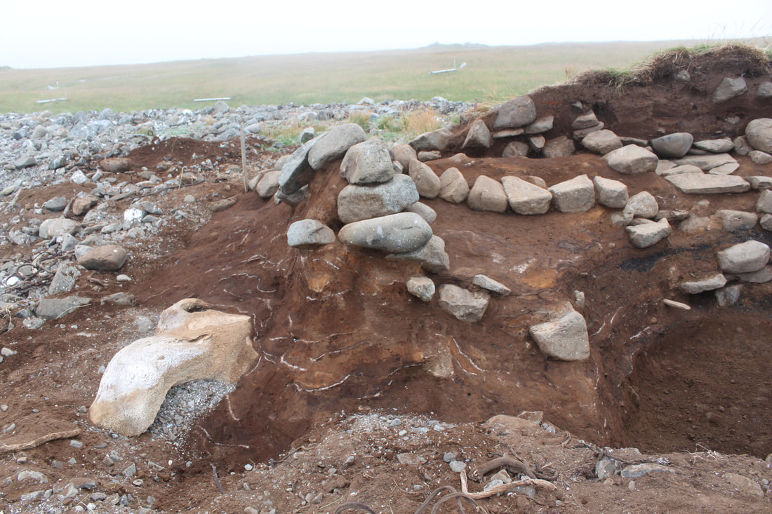 Archaeological site at Siglunes, Eyjafjörður; note large fragment of whale cranium in the left foreground. Photo reproduced with permission of Dr. Ramona Harrison, University of Bergen, and Fornleifastofnun Íslands (FSI). Despite these challenges, the Norse North Atlantic Marine Mammal Project and Brenna McLeod at the Frasier lab at St. Mary's University have identified over thirteen unique cetacean species within 200+ bone samples. In those samples, nine unique examples of Eubalaena glacialis have been genetically confirmed across the sampled site assemblages. Over the course of the next year, our project will continue to identify and analyze additional bone samples from across the North Atlantic. Microsatellite analysis of nuclear DNA from identified samples will help to refine which populations of North Atlantic right whales have been found across archaeological sites from North America, Iceland, Greenland, and the Orkney Islands. By 2020, our project will have analyzed over 400 whale bones and we hope to tell a number of species stories, not postscripts, on the whales of the North Atlantic. Selected Works Cited:
Active and Closed Unusual Mortality Events. NOAA Fisheries. https://www.fisheries.noaa.gov/national/marine-life-distress/marine-mammal-unusual-mortality-events Aguilar, Alex. “A Review of Old Basque Whaling and its Effect on the Right Whales (Eubalaena glacialis) of the North Atlantic.” Report of the International Whaling Commission, Special Issue 10 (1986): 191-199. Dunlop, D. M. “The British Isles according to Medieval Arabic Authors.” Islamic Quarterly 4 (1957): 11-28. Hreinsson, Viðar. Jón lærði og náttúrur náttúrunnar (Jon the Learned and the Nature of Nature). Reykjavik: Lesstofan Press, 2016. Laist, David W. North Atlantic Right Whales: From Hunted Leviathan to Conservation Icon. Baltimore: Johns Hopkins University Press, 2017. Lindquist, Ole. Peasant Fisherman Whaling in the Northeast Atlantic Area, CA 900-1900 AD. Akureyri: Háskólinn á Akureyri, 1997. Lindquist, Ole. “Whaling by Peasant Fishermen in Norway, Orkney, Shetland, the Faeroe Islands, Iceland and Norse Greenland: Medieval and Early Modern Whaling Methods and Inshore Legal Régimes.” In Whaling and History Perspectives on the Evolution of the Industry. Eds. Bjørn L. Basberg, Jan Erik Ringstad, and Einar Wexelsen. Sandefjord: Kommandor Chr. Christensens, 1995, 17-54. McLeod., B., M. Brown, M. Moore, W. Stevens, S. H. Barkham, M. Barkham and B. White. “Bowhead whales, and not right whales, were the primary target of 16th to 17th-century Basque whalers in the Western North Atlantic.” Arctic 61.1 (2008): 61-75. McLeod, B. et al., “DNA profile of a sixteenth century western North Atlantic right whale (Eubalaena glacialis).” Conservation Genetics (30 Jan. 2009). 10.1007/s10592-009-9811-6. “North Atlantic right whales on the brink of extinction, officials say,” The Guardian, 10 Dec. 2017. https://www.theguardian.com/environment/2017/dec/11/north-atlantic-right-whales-brink-of-extinction-officials-say Palumbi, Stephen R., "Whales, Logbooks, and DNA.” In Shifting Baselines: The Past and the Future of Ocean Fisheries, ed. by Jeremy B. C. Jackson, Karen E. Alexander, and Enric Sala, 163-173. Washington DC: Island Press, 2011. Proulx, J. ‘Basque Whaling Methods, Technology and Organization in the 16th Century.” Trans. A. McGain. In The Underwater Archaeology of Red Bay: Basque Shipbuilding and Whaling in the 16th Century, Volume 1, ed. R. Grenier, M. Bernier and W. Stevens, 42-96. Ottawa: Parks Canada, 2007. Rastogi, T., M.W. Brown, B. A. McLeod, T. R. Frasier, R. Grenier, S. L. Cumbaa, J. Nadarajah and B. N. White 2004. “Genetic analysis of 16th-century whale bones prompts a revision of the impact of Basque whaling on right and bowhead whales in the western North Atlantic.” Canadian Journal of Zoology 82 (2004): 1647-1654. Reeves, R. R., T. Smith and E. Josephson. “Near-annihilation of a species: Right whaling in the North Atlantic.” In S.D.Kraus and R. M. Roland (eds), 39-74. The Urban Whale: North Atlantic right whales at the crossroads. Cambridge MA: Harvard University Press, 2007. Roman, Joe and Stephen R. Palumbi. “Whales Before Whaling in the North Atlantic.” Science 301 (25 July 2003): 508-510. Soviet Illegal Whaling in the North Pacific: Reconstructing the True Catches. NOAA Fisheries, 2012. https://www.afsc.noaa.gov/quarterly/ond2012/divrptsNMML2.htm Szabo, Vicki. Monstrous Fishes and the Mead-Dark Sea: Whaling in the Medieval North Atlantic. Leiden: Brill, 2008. Teixeria, R. Venancio, and C. Brito. "Archaeological remains accouting for the presence and exploitation of the North Atlantic right whale Eubalaena glacilis on the Portuguese coast (Peniche, West Iberia), 16th to 17th century." PLOS One 2014 9(2): e 85971 / doi 10.1371/journal.pone.0085971 A Frigid Golden Age: Can the Society of Rembrandt and Vermeer Teach Us About Global Warming?2/27/2018
Dr. Dagomar Degroot, Georgetown University 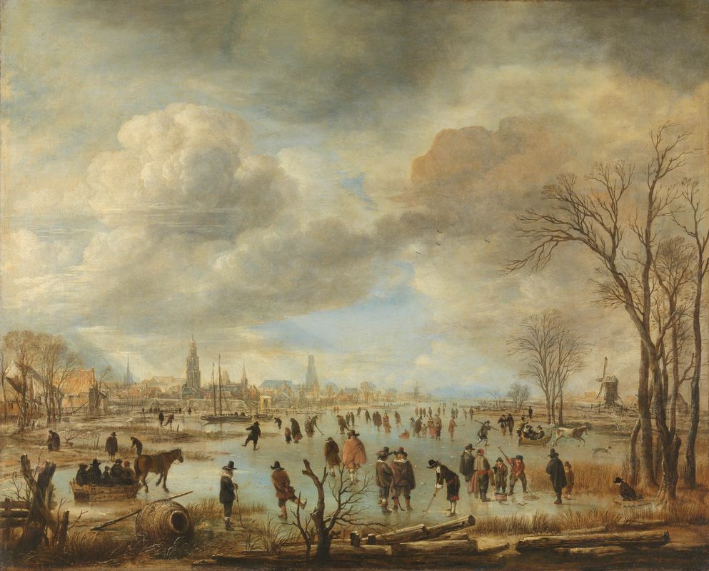 Aert van der Neer, “Riviergezicht bij Winter,” c. 1655-1660. Rijksmuseum Amsterdam Earth’s climate is changing with terrifying speed. Humanity has added several hundred billion tons of carbon dioxide to the atmosphere, strengthening a greenhouse effect that has now warmed the planet by roughly one degree Celsius. The scale, speed, and causes of today’s global warming have no precedent, but of course natural forces have always changed Earth’s climate. We now know that these changes were big enough to shape the fates of past societies. Most confronted disaster, but a few seemed to prosper in spite of – and in some cases because of – climate changes. Perhaps the most successful of all emerged in the coastal fringes of the present-day Netherlands. It has left us with lessons that may offer new perspectives on our fate in a warmer world. To contextualize present-day warming, paleoclimatologists have scoured the globe for signs of past climate change. They have found layers buried deep in glacial ice and cave stalagmites, sediments embedded in lakebeds and ocean floors, and rings wound around tree trunks and stony corals. All bear silent testament to ancient weather. Together, they reveal that, sometime in the thirteenth century, Earth’s climate started cooling. Huge volcanic eruptions lofted dust high into the stratosphere that blocked incoming sunlight. The Sun itself slipped into a dormant phase, sending less energy to the Earth. A long-running shift in Earth’s axial tilt gradually reduced the amount of solar energy that reached the northern hemisphere. Sea ice expanded, wind patterns changed, and ocean currents altered their flow. Patterns of precipitation fluctuated dramatically, bringing torrential rains to some places, and unprecedented droughts to others. A long “Little Ice Age” had begun. 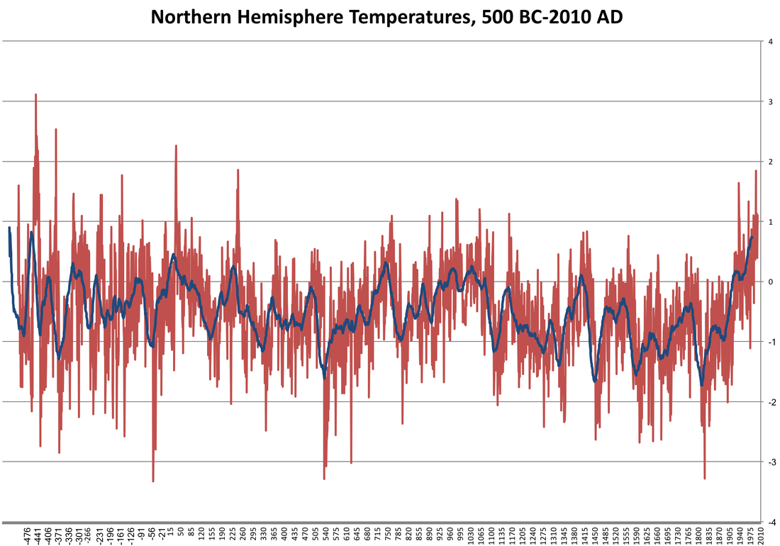 A tree ring reconstruction of average summer temperatures in the Northern Hemisphere over the past 2,500 years (red), with a thirty-year moving average (blue). The baseline (“0”) is the late twentieth-century average. Temperatures in the seventeenth century were cold but erratic. Developed from M. Sigl et al., “Timing and Climate Forcing of Volcanic Eruptions for the Past 2,500 Years,” Nature 523 (2015): 545. In the closing decades of the sixteenth century, this Little Ice Age reached its chilliest point across much of the northern hemisphere. By then, the world had cooled by nearly one degree Celsius, relative to average temperatures in the twentieth century. In many places, weather had also grown more volatile and less predictable from year to year, season to season. Despite its name, the Little Ice Age involved more than constant cooling. Historians, historical geographers, and archaeologists have argued that the onset of the coldest and most erratic phase of the Little Ice Age could not have come at a worse time. For centuries, populations in the greatest empires of the day had steadily increased. By the sixteenth century, millions depended on crops stubbornly cultivated in arid, unproductive farmland. When falling temperatures shortened growing seasons, when monsoons failed, or when storms flooded fields, harvests in these regions failed again and again. Many farmers responded by swapping crops that prefer warm, stable weather for those that cope better with cold, volatile conditions. Some diversified their fields. Yet often there was just no dealing with droughts, torrential rains, or cold snaps that lasted for longer than a year or two. Famine and then starvation spread from the plains of the Aztec Empire to the woodlands of the Mutapa Kingdom, from the steppes of the Grand Duchy of Moscow to the rice fields of the Ming Dynasty. The worst was yet to come. Temperature and precipitation extremes sickened plants and animals alike, compounding food shortages. As temperatures dropped, farmers huddled in huts with their ailing livestock. In those conditions, diseases spread easily from animals to people. Malnourished human bodies, meanwhile, have weak immune systems, which makes them easy prey for bacteria and viruses. Changing weather patterns also altered the range of insects that carried disease pathogens, bringing new and deadly ailments to the previously unexposed. In empire after empire, millions fled from the famine-stricken countryside, unwittingly infected by diseases that they carried to cities. Where famine lingered, epidemic outbreaks often followed. In one empire after another, the sick and starving blamed governments for their misery. They were usually right. Few governments responded constructively to the crises they faced, and most made them worse by, for example, increasing taxes or embarking on wars. The coldest stretch of the Little Ice Age therefore coincided with an unprecedented surge of revolts and civil wars. Rebel and state armies alike conscripted farm laborers from the already overburdened countryside, imposed new demands on marginal farmland, and joined refugees in spreading disease. In the end, millions died. Yet remarkably, inhabitants of the Dutch Republic – the precursor state to today’s Netherlands – enjoyed a Golden Age that perfectly coincided with the chilliest century of the Little Ice Age. Somehow, a country with about as many people as Providence, Rhode Island emerged as a European great power, with a navy that went from victory to victory, an army that held the mighty Spanish Empire at bay, and a commercial fleet that dwarfed all others. Today, the art of Rembrandt and Vermeer – painted in the coldest years of the Little Ice Age – gives a distant echo of the energy and prosperity of those incredible times. The Dutch Republic was something of an oddball in the seventeenth-century world. The overwhelming majority in most societies toiled in rural fields, growing crops for local markets. Many Dutch farmers, by contrast, cultivated cash crops for distant consumers. The republic therefore depended on a steady flow of grain imports from the rich and diverse farmland along the Baltic Sea. Over time, a growing share of Dutch citizens worked in commercial interests and industries with headquarters in or near port cities that would have been underwater, were it not for an extensive network of dikes and sluices. Urbanization rates were soon higher in the republic than they were just about anywhere else. Meanwhile, tens of thousands of sailors plied Dutch trades that reached deep into the Arctic, the Americas, Africa, and Asia. 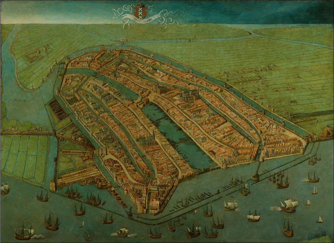 Amsterdam just before its rise to global prominence. Cornelis Anthonisz., “Bird's eye view of Amsterdam,” 1538. Amsterdam City Museum. Sailing depended on two things: favorable winds and open, ice-free water. By changing currents and cooling temperatures in the atmosphere and oceans, the chilliest stretches of the Little Ice Age therefore affected sailing as much as farming. Yet the impact was very different. New wind patterns actually sped up ships that left the republic for Asia or America, shortening their journeys. In the waters off northern Europe, storms were unusually frequent and severe in the coldest stretches of the Little Ice Age. Many ships foundered, and many sailors drowned. Yet crews aboard the republic’s biggest merchant ships – ones that carried the richest cargo from distant markets – weathered storms much better than sailors aboard other European ships. In fact, storms often benefitted Dutch sailors by further increasing the speed of these big ships. Even sea ice aided the Dutch, including in the Arctic. It took plenty of sea ice – but not too much – to redirect Dutch voyages of northern exploration towards the rich bowhead whale feeding grounds off the archipelago of Svalbard, which lies between the northern coast of Norway and the North Pole. Whalers from all over Europe soon set up shop there. For a long time, the edge of the Arctic pack ice lingered near Dutch whaling stations, and since whales gathered along the edge of the ice, the Dutch benefited. By following the ice edge west, Dutch whalers even found whale breeding grounds off the little island of Jan Mayen. The Dutch fought most of their wars on or around water. Climatic cooling may have benefited their armies and fleets even more than their merchants. The Dutch flooded their own farmland to thwart Spanish and later French invasions. Some of these floods would not have succeeded without torrential rains that reflected new atmospheric realities. Later in the seventeenth century, cooling coincided with a shift in the strength of atmospheric high and low pressure zones over the Atlantic Ocean, which sharply increased the frequency of easterly winds over northern Europe. Sailors aboard Dutch warships heading into battle from the republic often had what was then called the “weather gage:” the upwind position from a downwind opponent. That allowed them to decide exactly how and when to deploy new “line of battle” tactics, in which warships would sail by each other in single file while firing broadsides. New wind patterns played a role in helping the Dutch win wars they might otherwise have lost. 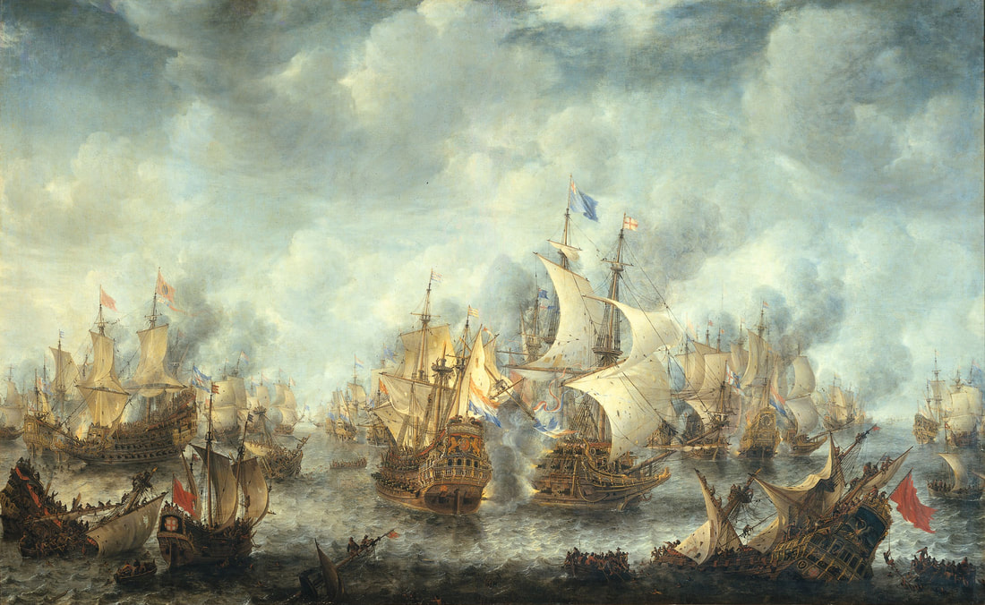 The wind blows from the left to the right in this painting from the First Anglo-Dutch War (1652-54). The Dutch ship in the center therefore has the weather gage, while the English flagship it is fighting does not. Jan Abrahamsz. Beerstraten, “Slag bij Ter Heijde,” 1653-1666. Rijksmuseum Amsterdam. Still, climate change did not always aid the Dutch. In the Arctic, sea ice crushed ships, drowned sailors, and screened whales from whalers. Sailors in small ships that carried grain and timber from the Baltic Sea endured violent storms and confronted thick sea ice that blocked their way. Cold snaps in the Baltic occasionally led to harvest failures that imperiled the republic’s precious grain imports. Ice repeatedly blocked the waterways of the republic, suffocating travel between cities and raising the specter of flooding when the ice thawed. Sometimes, ice froze rivers that otherwise served as barriers to invasion. Left unattended, candles and stoves in cold winter weather kindled fires that swept through the cities of the republic. Time and again, the Dutch responded creatively. Shipwrights fortified the hulls of whaling ships and greased them until they slid off ice. Civilians and soldiers hacked through ice to preserve open water in their defensive rivers. Guilds and city governments bought icebreakers that not only kept waterways open, but actually manufactured ice blocks for use in cellars. When the ice was too thick, the Dutch used skates and sleds to turn frozen canals into busy thoroughfares. Merchants divided their goods between different ships, and invested in marine insurance. They stockpiled Baltic grain in good years, and sold it for healthy profits whenever food shortages plagued Europe. Charities maintained a steady supply of food for the urban poor. Inventors pioneered new firefighting tactics and equipment, and made good money selling them across Europe.  Jan van der Heyden’s “Fire Hose Book” depicts the storm-kindled fire of July 27th, 1679. Jan van der Heyden, “Oude brandspuiten en nieuwe slangbrandspuiten in de praktijk,” print, 1690, Rijksmuseum Amsterdam. The Dutch, in short, were lucky to benefit from environmental changes that favored their unusual economy. But they also made their own luck. The society they built ended up being remarkably resilient in the face of new weather patterns that spelled disaster elsewhere in Europe. By relying so heavily on farmers scratching out a meagre existence on marginal farmland, other civilizations developed vulnerabilities to climate change that simply did not exist in the Dutch Republic. In fact, the Dutch may even have adapted their technologies and policies to exploit the Little Ice Age, though they may not have recognized the trends in weather that we call climate change. Why were they so flexible in the face of changing environmental circumstances? In part, the answer may lie in their long history of draining and damming the Low Countries. The Dutch long understood that environments can change, and that societies can either adapt or succumb. There was a darker side to the republic’s prosperity. The Dutch thrived in part by preying on communities and civilizations the world over. They shattered Iberian trading monopolies in Asia, seized expansive territories in the Americas, overwhelmed English whalers in the Arctic, and infamously broke into an African slave trade that cruelly exploited millions of people. The weather extremes of the Little Ice Age had often weakened communities that the Dutch victimized. In the republic, adaptation to climate change could take the form of a parasitic kind of opportunism that leveraged vulnerabilities in other societies. What, then, can the history of the republic’s frigid Golden Age teach us today? First and perhaps most importantly, it shows us that even relatively small changes in Earth’s average temperature can have enormous social consequences. Across much of the seventeenth-century world, the gloomiest predictions for our warmer future came true. A third of humanity may have died in disasters either set in motion or worsened by climate change. The world has already warmed more, relative to average temperatures in the twentieth century, than it cooled in the chilliest stretches of the Little Ice Age. Our best projections suggest that it will warm by roughly three degrees Celsius in the coming century, if and only if countries follow through on their Paris Agreement pledges. Histories of the Little Ice Age therefore give us an urgent call to arms. We have technologies that our ancestors could not have imagined. But there are far more of us, consuming unimaginably more plants and animals, metals and fuels. And we too depend on a huge network of fields and fisheries that may not survive drastic changes in temperature and precipitation. That leads us to our second lesson: climate change has had, and probably will have, very unequal consequences for different societies, communities, and individuals. Many assume that rich societies cope best with climate change. Yet some of the wealthiest seventeenth-century empires actually fared worst in the coldest and most volatile years of the Little Ice Age. Climate change, it seems, imperils not only societies that have few resources to exploit, but also those that require abundant resources to prosper. The Dutch thrived in the seventeenth century not because their republic was rich, but because much of its wealth derived from activities that climate change benefited. Today, we can learn from the republic by strengthening social safety nets, investing in technologies that exploit or reduce climate change, and more broadly by thinking proactively about how we will adapt to the warmer planet of our future. We can learn from the Dutch in another way too, by strengthening bonds between countries and communities, rather than preying on the most vulnerable. Ultimately, the lessons of the past come to us in the form of parables: stories that hint at deeper truths but do not tell us exactly what to do. That does not make them any less valuable. We now know that we cannot ignore our changing climate, that it will shape our fortunes in the decades to come. Let us use the warnings of the past to confront the looming catastrophe in our future, while we still can. This article summarizes some important ideas in my new book, The Frigid Golden Age: Climate Change, the Little Ice Age, and the Dutch Republic, 1560-1720. You can buy the hardcover on the Cambridge University Press website or on Amazon, and you'll soon be able to purchase the paperback.
The Washington Post published a modified and much shorter version of this article. You can find it here. Dr. Ruth Morgan, Rachel Carson Center for Environment and Society  Protest in Bonn at the start of COP 23. Photo by Spielvogel. I joined the most recent UN Climate Change Conference in Bonn with a delegation from Monash University, which also included legal scholars, renewable energy specialists, and science communicators. The opportunity to observe and participate in the activities that accompany the negotiations was too good to pass up. Both personally and professionally, I have closely followed the machinations of international climate politics over the past decade, with particular attention to the work of Australian scientists and policymakers in the past and present. Attending and participating in the conference offered the chance to see firsthand how delegates and other actors negotiate and deliberate to shape the future of our planet. Here, I reflect on the different ways that the past inflected these discussions, and how they resonate with the fields of climate and environmental history. With Fiji presiding, the COP23 had the specific goal of preparing the implementation phase of the Paris Agreement. Having celebrated the achievements of Paris in 2015, now was the time to get down to work to ensure that the rise of global temperatures is limited to 2 Celsius or below. The organisation of COP23 was such that intergovernmental negotiations took place in the ‘Bula Zone’, while about two kilometres away in the Rheinaue Leisure Park was the ‘Bonn Zone’, where governments and all manner of non-governmental organisations showcased their work in events, exhibits, and demonstrations. I was granted access only to the latter; I gathered from colleagues and other participants that the distance between the two spaces was a shortcoming because it isolated negotiators from the energetic atmosphere in this area, while diminishing the transparency and openness of the negotiations. In observing how national interests shape global climate policies, I was especially interested in representations of economic development, adaptation, and climate justice, and how these informed the discussions at the COP23. These issues are inherently historical in nature, processes spurred by global configurations of imperialism, capitalism, and (de-)colonisation since at least the eighteenth century. With the small island nation of Fiji as co-host of the meeting, these concerns were front and centre for the duration of the event. The strong cultural presence of Fiji in both the Bula (meaning ‘welcome’) and Bonn Zones ensured that there was both a sense of place and a sense of urgency to the negotiations. As the Fijian Prime Minister Frank Bainimarama reminded attendees on the eve of the conference, we are ‘all in the same canoe’.  COP23 hoardings outside the building that once hosted the Deutsches Bundestag. Photo by author. Here, the inequities of anthropogenic climate change were palpable. Among the worst-affected by the increased frequency and magnitude of extreme weather events of a warmer planet will be those former colonies, such as the low-lying islands of the Pacific, that comprise the Global South. There is a dark irony, as Dipesh Chakrabarty and others have argued, that these peoples and places are bearing the brunt of a planetary phenomenon to which they have contributed little. They have received little of the benefits from economic growth associated with increased carbon dioxide emissions, but face the most immediate costs with the fewest resources to adapt. Having recently relocated the village of Vunidogoloa in the face of flooding and coastal erosion, and with plans to relocate many more, Fiji symbolized just what was at stake in Bonn.  The Adi Yeta on display in the Bula Zone. This drua is an 8-metre long traditional double-hulled, open ocean sailing canoe. Made from tropical hardwood and coconut fibre, the Adi Yeta was built in Suva, Fiji several years ago and was shipped to Bonn from the National Maritime Museum in Greenwich, UK. This drua will be permanently displayed in their new Pacific Encounters gallery in late 2018. Photograph courtesy of UNFCCC COP23. The display and performance of the nation’s culture and history in both zones reinforced this symbolism. Each day, members of the Fijian delegation danced, sang and practiced traditional crafts and ceremonies, enlivening the conference with these colourful and moving expressions of ‘bula’ (also meaning ‘life’). The adoption of the Fijian and Pacific word ‘Talanoa’ to describe forthcoming facilitative discussions (the ‘Talanoa dialogue’) will hopefully ensure that this presidency leaves a lasting local impression on the UNFCCC process. The attention to material culture continued on the conference fringe, with public art in the Rheinaue Park providing a meaningful connection between the Bula and Bonn Zones that underscored the urgent need for climate action. One striking piece created a ‘sign forest’ of rallying cries from past and current social and environmental campaigns. Suggesting the connection between these movements and the current climate crisis highlighted a sentiment I heard expressed throughout conference that ‘people power’ (and non-state actors) can give ‘confidence’ to governments to act on climate change. Another moving sculpture was ‘Unbearable’, by Danish artist Jens Galschiøt, which depicted a polar bear impaled on an oil pipeline curved upwards to represent increasing carbon emissions. These works, together with the fascinating Wetterbericht (‘Weather Report’) exhibition at the nearby Bundeskunsthalle, reinforce the important role of the arts and cultural institutions in ‘supporting conversation about and action on’ climate change, as the editors of Curating the Future argue.  What When by British artist collective Stan’s Café. Photo by the author These exhibits combined with reports of a spike in carbon emissions this year, to remind us of just how far we had come and how far we had to go. At the Bonn headquarters of the UNFCCC, an exhibition celebrated over two decades of international climate change diplomacy, with Paris the crowning achievement to date. But others argued we had not come far enough: Uppsala University’s Zennström Professor Kevin Anderson despaired at the failure of “his” generation to curb emissions and to convince governments of the urgent need for action. Speakers turned to the past to reinforce their message. For Anderson, only an international effort on the scale of the Marshall Plan (1948-51) would come even close to meeting the aims of the Paris agreement. Others pointed to the Montreal Protocol (1989) and its impacts as an example of what could be achieved through international cooperation. These examples left me uncertain as to how instructive they might be for our current condition. On the one hand, they buoy our hopes that change can happen, while on the other, their circumstances suggest the key to action is an agreed threat – whether communism or CFCs. Amid the diffusion of expertise and authority that currently typifies Western liberal democracies, just how we can reach that common ground remains to be seen.
At the very least, these references to historic examples provided temporal markers to accompany the conference’s emphasis on the materiality of climate change. Fiji’s presidency and the displays of material culture that accompanied many delegations reminded participants that climate change, while a planetary crisis, manifests at the local level. The ‘sea of islands’ of the Pacific, the littoral, coastlines, were all sites where climate change was manifesting. Together, their evocation also suggested the importance of the physical properties of the ocean in our understandings of the climate crisis. Although there was certainly plenty of techno-optimism in the air, many speakers and observers emphasised the importance of engaging with other forms of knowledge. One project involved sharing the fire cultures of Aboriginal Australians with local peoples in Botswana. This initiative was one of many that reflected the meeting’s more inclusive approach regarding First Peoples, whose care for country was finally acknowledged as vital for climate change adaptation and mitigation efforts. FAO Director-General José Graziano da Silva, meanwhile, lamented the impact of the Green Revolution on the ‘old ways’ of agricultural production. Both moments spoke to the urgency of redressing the troubling legacies of ‘improvement’ and Western hubris, and for the empowerment of local peoples at home and abroad. For many participants, such empowerment lay in their faith. Church leaders from the Pacific, Californian Governor Jerry Brown, and former Irish President Mary Brown, for instance, all reflected on the importance of their faith to themselves and to their communities. Worship offered a culture of coping that connected them to each other and to a higher power, while providing an existential framework to make sense of environmental challenges. They and others invoked Pope Francis’ 2015 encyclical on the environment as a source of inspiration and hope that emphasised climate justice for all. COP23 was not without its contradictions. Just fifty kilometres away from the host city, for instance, is the site of one of Europe’s biggest sources of CO2 emissions: the large open-cast lignite coal mine near Cologne. Thousands of demonstrators converged there to urge the German government to phase out the mining activity and to deliver on its progressive climate rhetoric. Meanwhile, the Australian government proudly announced further contributions to climate change adaptation measures in Oceania, but were less inclined to discuss the future of the Adani coal mine or the health of the Great Barrier Reef. These examples alone speak to the complex knot of labour, energy and conservation that continue to stymie climate action. Perhaps the greatest contradiction of them all was the sheer size of the meeting, and its accompanying carbon footprint. So great were the demands of hosting such a conference that Fiji was unable to hold the event at home. To the enormous infrastructure required for the meeting itself, add the toll of international travel of some twenty thousand delegates and observes – it all makes for an eye-watering sum. Many scholars in the sciences and humanities have long questioned the environmental ethics of conference travel (particularly by air), and are exploring alternative ways for meaningful and productive scholarly exchange. Geography certainly presents something of a challenge for Australian academics, but taking a more strategic and judicious approach to the frequency of my own travels will be an important start. Attending COP23 made it clear to me that learning how to live and work more lightly is a challenge I can no longer afford to ignore. Katrin Kleemann, Rachel Carson Center  This picture shows the river Skaftá. The village Kirkjubæjarklaustur is located on the other side of the river. The size of the buildings and trees gives you an idea of how wide the river is. It was vaporized and replaced by lava in 1783. Photo: Katrin Kleemann, 2016. “June the 9th [1783] was a day of clear weather, during which the cloud [north of the mountains] quickly rose higher and higher. In the evening a great downpour fell from it. The flow of the river Skaftá, a stream so great that at the ferry site here horses had to swim some seventy fathoms to cross it, and which ran eastward along the Síða area, now began to decrease substantially, however. On the 10th […] the river Skaftá had dried up entirely, except for the water emptying into it from local streams. […] On the 12th the weather was clear, with a wind from the south. Now the flood of lava spilled out of the canyon of the River Skaftá and poured forth with frightening speed, crashing, roaring and thundering. When the molten lava ran into wetlands or streams of water the explosions were as loud as if many cannon were fired at one time. At first this fiery flood followed the main course of the river, and then spread over the banks, and out over the older lava fields which stretch out on both sides […].” Jón Steingrímsson (1728-1791), local reverend, who wrote a diary In June 1783, the residents of Kirkjubæjarklaustur, an Icelandic village, watched as the water of their local river Skaftá vanished and, days later, was replaced by a “fiery flood” of lava. They could not have imagined that this event would have consequences halfway around the globe, all the way to eastern Africa. It suppressed the Nile’s summer floods and thereby helped cause a famine in Egypt, where agriculture depends on those floods. That summer, the 27-kilometer long Laki fissure, remotely located in the Icelandic highlands to the southwest of Vatnajökull, Europe’s largest glacier outside the Arctic, began an eight-month-long eruption. It released the largest amount of lava of any eruption in the last millennium, as well as huge quantities of sulfur dioxide, fluorine, and other gases. The consequences would be catastrophic for Iceland’s population. The eruption did not kill anyone directly, but Laki's gases, especially the fluorine, poisoned the fields and thereby killed a large percentage of Iceland's cattle, horses, and sheep. The people of Iceland, deprived of their main food source, soon suffered malnourishment and starvation. These “hardships of the mist“ - today remembered as móðuharðindin - lasted until 1785, and claimed the lives of about a fifth of Iceland's population. Some 10,000 people perished. 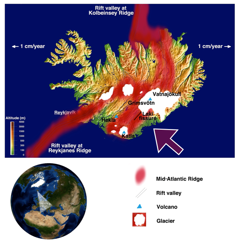 This image shows the position of Iceland and the direction in which the dry fog was blown; it also shows the position of the Mid-Atlantic Ridge and the three major volcanoes in Iceland. The Laki fissure is just southwest of the Vatnajökull ice shield. This map was created by Katrin Kleemann and is built upon map materials from Gingko Maps, which are licensed under a CC BY 3.0 license. In the rest of Europe, a strange sulfurous-smelling "dry fog" lingered for around two months. The levels of sulfur dioxide in the atmosphere were comparable to present-day extreme air pollution events. In France and England, contemporaries reported sore eyes, skin irritations, respiratory problems, and damage to vegetation. Today, this dry fog is referred to as volcanic smog, or “vog,” and we know it can worsen cardiorespiratory illnesses. Volcanologist Anja Schmidt has used climate models to simulate what would happen if a Laki-style eruption occurred today. She found that excess mortality - that is, deaths that would not have occurred otherwise - would be 142,000 deaths within a year of the eruption. In 1783, the news of a volcanic eruption in Iceland reached Europe only in September, after the fog had vanished. It took another decade for an Icelandic expedition to find the Laki fissure, and roughly one century for scientists to connect the dots between the eruption and the dry fog it caused. It would not be as long, however, before even bigger eruptions would have still more destructive consequences for human lives and livelihoods. 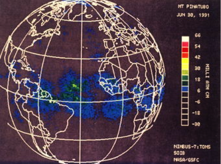 An image from NASA’s TOMS satellite on 30 June 1991, showing the global circulation of Pinatubo’s ash. Volcanic eruptions can cause climate change if they release large amounts of sulfur dioxide high into the stratosphere. Sulfur dioxide oxidizes into sulfuric acid aerosols, which reflect incoming solar radiation. The troposphere, which is the atmospheric layer in which we live and in which our airplanes fly, experiences cooling, whereas the stratosphere, the layer above the troposphere, which starts at 18 km near the equator and around 9-13 km in the high latitudes, heats up. Other gases released from eruptions, such as carbon dioxide, are greenhouse gases and contribute to the warming of the planet. Yet overall, big eruptions that send sulfur dioxide into the stratosphere can cause profound, if relatively short-lived, cooling. The biggest eruption in recent centuries was that of Tambora in 1815. It reached a 7 on the volcanic explosivity index (VEI), a logarithmic scale from 0 to 8 in which each level registers a tenfold increase in explosivity (measured in volume of ejecta and eruption height). By contrast, the eruption of the Laki fissure "only" reached a 4. Tambora exploded in present-day Indonesia, at a tropical latitude where trade winds - the persistent easterly winds north and south of the equator - helped to spread its aerosols around the globe. Thanks to this global dispersal, evidence of tropical volcanic eruptions can be found in Greenland and Antarctica. Glaciologists study layers of compressed snow and bubbles of preserved air in ice cores to reconstruct the climate of the past. In the cores, they also find layers of ash, tephra, and gases such as sulfur - byproducts of volcanic eruptions - which help them to date the ice layers. High latitude eruptions such as the Laki fissure eruption only deposit ash and tephra in one hemisphere. Tambora’s impact on Earth's climate was magnified as the volcano erupted in the aftermath of a very strong eruption in 1809 (VEI 6), which has not yet been localized. Both eruptions occurred in a period of low solar activity known as the Dalton Minimum (ca. 1790-1830). In 1816, Tambora therefore brought a bitterly cold "year without summer" to the Northeastern United States, as snow and frost ruined crops as late as June. Cooler temperatures and heavy rains also plagued Ireland and the rest of Europe, which helped provoke famine. Tambora also delayed the summer monsoon in India, where unseasonal and torrential rain helped cause flooding, crop failures, famine, and ultimately a cholera epidemic. 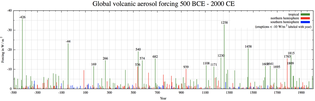 This figure is based on Michael Sigl et al. 2015. It shows large volcanic eruptions, which occurred in the tropics (green), in the northern hemisphere (red), and in the southern hemisphere (blue). This graphic was created by DeWikiMan, and it is licensed under a CC BY 3.0 license. The graphic also shows that several volcanic eruptions can occur at around the same time, increasing their effect on the climate and thus their impact on societies. A series of volcanic eruptions coincided with the massive 1257 Samalas eruption in today’s Indonesia, for example, and the 1458 Kuwae eruption in today’s Vanuatu. Eruptions in quick succession, including in 1595 (Nevado del Ruiz in today’s Colombia) and 1600 (Huaynaputina in today’s Peru), caused a June-July-August temperature anomaly between 1600 and 1609. In 2012, Gifford H. Miller was the lead author of an article that argued that large volcanic eruptions in the late thirteenth century might have initiated the abrupt onset of the Little Ice Age, which was then sustained for six centuries by so-called feedback loops between the ocean, sea ice, and the atmosphere. The climate system on Earth is sensitive to change and different parts of the system, solar radiation, sea ice, cloud cover, wind and ocean currents, are interconnected. One important feedback loop is the albedo effect, which relies on the fact that a white surface, such as ice, reflects more sunlight back into space than a dark surface, such as the ocean. When a series of strong eruptions at the beginning of the Little Ice Age cooled the global climate, sea ice and therefore the albedo effect increased, the Earth absorbed less solar radiation, and average global temperatures began a long and sustained decline. The resulting climatic shift was then reinforced by a series of large eruptions around 1458. Changes in solar radiation, Earth's rotation, and major patterns of oceanic and atmospheric circulation may also have contributed to the cooling, but volcanic eruptions were most to blame. 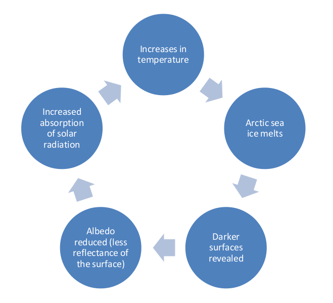 This figure illustrates the processes of the ice albedo effect, which in the present time is characterized by a warming and melting Arctic. During the Little Ice Age, the cycle was reversed. The biggest concern of our present time is anthropogenic climate change and global warming. Interestingly, global warming is actually increasing the chances of volcanism in the cold parts on Earth. In many cold places, such as Iceland, there still are large ice shields, reminders of the last Ice Age, which are melting away in a warming world. The melting of these heavy ice shields takes away a weight, which causes an uplifting process of the land below, called the postglacial rebound effect. In volcanically active regions, the ice shields were resting on top of magma chambers, with the decrease of weight the magma chambers can produce more magma and grow, and thus making a volcanic eruption more likely than before. In most extreme cases, the constant melting of Iceland’s glaciers could lead to an Eyjafjallajökull 2010 size eruption every seven years. Even a large volcanic eruption and a short-term cooling, similar to the Pinatubo eruption of 1991, would not change this warming trend in the long run. New research suggests that even a Tambora style eruption in 2085 would likely not offset global warming simply because the oceans will be considerably warmer than they were in 1815. Another recent paper by lead author Ingo Bethke revises climate models by including sixty potential but fictional, large eruptions over the course of the twenty-first century. Most models actually ignore the potential of such eruptions. Yet the paper concludes that future eruptions are “unlikely to mitigate long-term anthropogenic climate change.” Today, in our warming world, there are international efforts to cut greenhouse gas emissions to tackle anthropogenic climate change. Yet some scientists are also exploring ways to alter the climate through geoengineering, in order to stop the anthropogenic warming spiraling out of control. There are two different geoengineering categories: the first involves the removal of greenhouse gases such as carbon dioxide emitted by burning fossil fuels from the atmosphere, while the second involves managing solar radiation. Schemes in this second category would initiate a process of making the planet absorb less solar radiation to offset the consequences of the large-scale fossil fuel emissions of the recent past and present. Geoengineers pursuing projects in this secondary category have been inspired by the cooling consequences of volcanic eruptions. However, the onset of the Little Ice Age, and the Nile floods that accompanied the small Icelandic eruption in 1783, both reveal the risks of such geonengineering schemes. The climate system is interconnected and incredibly sensitive to change. Reproducing the effects of a large volcanic eruption is both risky and dangerous, since we cannot know all the implications and potential consequences of such an endeavor. The long history of volcanic disasters therefore provides a warning for our warmer future.  This image shows the northeastern part of the Laki Fissure as seen from Mount Laki, extending towards the Vatnajökull ice shield. Photo: Katrin Kleemann, 2016. Selected Works Cited:
Bethke, Ingo, Stephen Outten, Odd Helge Otterå et al. “Potential Volcanic Impacts on Future Climate Variability.“ Nature Climate Change 7 (2017): 799-805. Cole-Dai, Jihong, David G. Ferris, Alyson L. Lanciki, et al. “Two Likely Stratospheric Volcanic Eruptions in the 1450s C. E. Found in a Bipolar, Subannually Dated 800 Year Ice Core Record.“ Journal of Geophysical Research: Atmospheres 118 (2013):7459-7466 Courtillot, Vincent. “New Evidence for Massive Pollution and Mortality in Europe in 1783-1784 may have bearing on global change and mass extinctions.” Comptes Rendus Geoscience 337 (2005): 635-637. D’Arcy Wood, Gillen. Tambora. The Eruption that Changed the World. Princeton: Princeton University Press, 2014. Fasullo, J. T., R. Tomas, S. Stevenson, et al. “The Amplifying Influence of Increased Ocean Stratification on a Future Year Without a Summer.“ Nature Communications 8 (2017). Doi: 10.1038/s41467-017-01302-z Grattan, John, M. Durand, and S. Taylor. „Illness and Elevated Human Mortality in Europe Coincident with the Laki Fissure Eruption.“ In Volcanic Degassing, edited by Clive Oppenheimer, D. M. Pyle, and J. Barclay, 401-414. London: The Geological Society of London, Special Publication 213, 2003 Grattan, John, Roland Rabartin, Stephen Self, and Thorvaldur Thordarson. “Volcanic Air Pollution and Mortality in France 1783-1784.“ Comptes Rendus Geoscience 337, no. 7 (2005): 641-651 Lavigne, Franck, Jean-Philippe Degeai, Jean-Christophe Komorowski, et al. “Source of the Great A.D. 1257 Mystery Eruption Unveiled, Samalas Volcano, Rinjani Volcanic Complex, Indonesia.“ PNAS 110, no. 42 (2013): 16742-16747. Longo, Bernadette M., W. Yang, J.B. Green, et al. “Acute Health Effects Associated With Exposure to Volcanic Air Pollution (Vog) From Increased Activity at Kilauea Volcano in 2008.” Journal of Toxicology and Environmental Health 73 (2010): 1370-1381 Manning, Joseph G., Francis Ludlow, Alexander R. Stine, et al. “Volcanic Suppression of Nile Summer Flooding Triggers Revolt and Constrains Interstate Conflict in Ancient Egypt.“ Nature Communications 8 (2017). Doi: 10.1038/s41467-017-00957-y. Miller, Gifford H., Áslaug Geirsdóttir, Yafang Zhong, et al. “Abrupt Onset of the Little Ice Age Triggered by Volcanism and Sustained by Sea-Ice/Ocean Feedbacks.“ Geophysical Research Letters 39 (2012). Doi:10.1029/2011GL050168 Robock, Alan. “Pinatubo Eruption: The Climatic Aftermath.“ Science 295 (2002):1242-1244. Robock, Alan, “The Latest on Volcanic Eruptions and Climate.“ EOS Trans. AGU 94, no. 35 (2013): 305. Schmidt, Anja, Bart Ostro, Kenneth S. Carslaw, et al.: “Excess Mortality in Europe Following a Future Laki-Style Icelandic Eruption.“ PNAS 108, no. 38 (2011) :15710–15715 Schmidt, P., B. Lund, C. Hieronymous, et al. “Effects of Present-Day Deglaciation in Iceland on Mantle Melt Production Rates.“ Journal of Geophysical Research Solid Earth 118 (2013) :3366-3379. Sigl, Michael, M. Winstrup, J. R. McConnell, et al. "Timing and Climate Forcing of Volcanic Eruptions for the Past 2,500 Years.“ Nature 523 (2015): 543-549 Sigl, Michael, and Matthew Toohey. ”Volcanic Stratospheric Sulfur Injections and Aerosol Optical Depth From 500 BCE to 1900 CE.” Earth Syst. Sci. Data 9 (2017): 809-831. Steingrímsson, Jón. Fires of the Earth. The Laki Eruption 1783-1784, translated by Keneva Kunz, 25-26. Reykjavík: University of Iceland Press and Nordic Volcanological Institute, 1998. Dr. Sam White, Ohio State University.  In August 1559, the aspiring conquistador Tristán de Luna y Arellano brought some five hundred soldiers and a thousand colonists from New Spain to a settlement on Pensacola Bay, Florida, which he declared “the best port in the Indies.” The viceroy of New Spain reported to the king “the port is so secure that no wind can do them any damage at all.” Even as he wrote, a hurricane was entering the Caribbean, poised to devastate Puerto Rico. A week later, it roared into Pensacola Bay. Tristán de Luna had no experience of tropical storms that could overwhelm even the strongest harbors. He had left all the settlement’s supplies aboard his ships in the bay. Food, clothing, arms, and armor all went down to the bottom of the sea with the wreck of his largest vessels. Only two small boats survived to take the sad news back to the viceroy in Mexico City. Within months, the colony unraveled amid hunger, exposure, infighting, and Native American resistance. When the survivors were finally evacuated, they came home complaining of Luna’s erratic leadership and the region’s “bad climate.” Despite the scale of his expedition, and its chance to change the history of colonial America, few Americans today have even heard of Tristán de Luna. On the whole, that first century of European explorations and colonizing ventures in North America remains largely forgotten among the American public, more legend or Disney storytelling than real substance. That forgetfulness is a shame for two reasons, as I’ve come to learn my research. First, the real stories of those early expeditions are a lot more fascinating than the Disney version. Second, they present object lessons in the challenges of climate change that could be surprisingly relevant today. 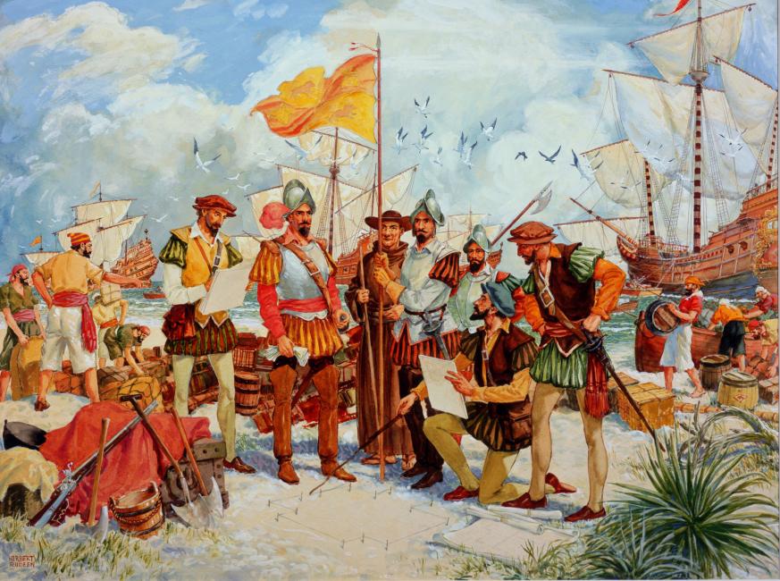 "1559 Landing of Tristan de Luna at Pensacola." Herbert Rudeen, 1959. Like many historians who study past climate and weather, I stumbled across my topic – the climate history of North America - by accident. As a graduate student, more than a decade ago, I was preparing a dissertation on the suitably obscure topic of agrarian crises in early modern Anatolia. What I discovered was that the Ottoman Empire, which then ruled the whole Eastern Mediterranean, had been unprepared for the onset of the coldest and (in that region) the driest phase of the Little Ice Age, from the late 1500s to late 1600s. Freezing winters and droughts, harvest failures and the death of livestock brought famines and undercut provisioning systems that the empire needed to supply its cities and armies. Soldiers mutinied; peasants and pastoral tribes rose up in rebellion; rural populations perished or fled; and the empire barely survived the chaos. Published just as the Syrian civil war began, my first book, The Climate of Rebellion in the Early Modern Ottoman Empire, could have been a parable about the dangers of climate-driven conflict. Nevertheless, I was aware of the differences as well as the parallels between past and present. Neither the Ottoman crisis then nor the Syrian crisis now can be reduced to just climate change. Climate vulnerabilities have changed a lot in four centuries, in no small part because people in Ottoman times didn’t know that they were living through climate change. What we now recognize as the Little Ice Age was to them just a series of unforeseeable disasters. Today global warming is a much-discussed topic, and we all (should) know that climates are changing. Our challenge is how to imagine our future climates and adapt to them. So I wanted to find another historical example with parallels to our present situation.  That became one motivation to write a new book (left) about climate and colonial North America. When Europeans first came to the New World they weren’t expecting a change of climates. Received wisdom was that climates were more or less the same everywhere along the same latitudes. However, experience from the time of Columbus onward revealed that the Americas had different weather patterns and different seasons, even on the same parallels. The tropics were not the uninhabitable “Torrid Zone” that ancient authors had supposed them to be, while the continental seasons of North America turned out to be much more variable than in the maritime climates of Western Europe. The challenge for Europeans was to make sense of that change in climates and plan their expeditions accordingly. They had to decide where to explore or settle, what clothes to bring and crops to plant, often based on nothing more than rumors, hearsay, or passing observations. Planners and promoters of these expeditions tended to fill the gaps in their knowledge with self-serving rationalizations. Early voyages in search of a Northwest Passage over Canada epitomized the problem. Every encounter with extreme cold or sea ice could be explained away as some local aberration or accident. Similar rationalizations led Spaniards to look for Mediterranean conditions and a “new Andalusia” in Georgia and the Carolinas, and inspired English visions of silk, spices, and sugar in Virginia and even New England. For this reason, early European explorers and colonists were sure to be disappointed with the climates of North America. What turned disappointment into disaster were the extreme conditions typical of the Little Ice Age. On examining the range of proxy and written evidence for North American climates, I found the same sort of anomalies that caused trouble for the Ottoman Empire. The epic drought and extreme cold during Jamestown’s “starving time” of 1609-10 is only the most famous example. In the 1540s, Spanish expeditions in California, the Southwest, and Southeast all encountered freezing winters with heavy snows where they would rarely be found today.  A seventeenth-century depiction of the Jamestown colony, which settlers briefly abandoned amid a long drought. Then from the late 1500s to the turn of the 17th century, a series of large volcanic eruptions brought global temperatures lower still. In 1601, for instance, the Rio Grande froze over near today’s Albuquerque; frost and drought brought famine to the Pueblos; and Juan de Oñate’s conquest of New Mexico nearly collapsed from hunger and desertions. French settlers in New England and Canada perished in the long winters that decade, and the little-remembered English colony at Sagadahoc, Maine gave up in 1608 after less than a year, its “hopes . . . frozen to death” in the words of one contemporary.
Cold and drought, as well as storms, afflicted colonial expeditions in different ways. Crops failed and animals died. Diseases spread from exposure, poor water supplies, and malnutrition. Long winters without fresh food brought scurvy. Supply ships were lost when needed most. Competition for food and fuel engendered conflict between European invaders and Native Americans, who also had to adapt to Little Ice Age conditions. Yet evolving perceptions of North America’s climates were just as consequential as realities. Years or even decades of experience with parts of the continent did not always translate into realistic appraisals of their climates or accurate planning. Sometimes when the high hopes of early expeditions met the shock of unexpected extremes, they gave way to exaggerated disparagement and despair. Around the 1570s, after decades of disappointment, Spanish officials began to dismiss the whole of La Florida (today’s Southeastern United States) as “worthless,” and the near collapse of Spanish New Mexico left a similarly negative impression among officials in Mexico and Spain. The failure of the Sagadahoc colony killed interest in New England for over a decade: “the country esteemed as a cold, barren, mountainous, rocky desert,” in John Smith’s words. Settlers in the Jamestown colony, however, refused to acknowledge Virginia’s environmental challenges. Their leaders blamed any problems on the colonists themselves and insisted the region was as temperate and fertile as anywhere in Europe. They became, in a sense, America’s first climate change deniers, sending thousands of colonists to early graves across the Atlantic. The climatic vulnerabilities of the modern world may bear little resemblance to the struggles of isolated colonies four or five centuries ago. But human psychology has probably changed much less. It is easy now, as it was back then, to embrace denial or despair. It is a lot harder to adjust expectations, make new investments, or accept a different way of life than the ones we’re used or have planned on. With Hurricane Harvey, the Houston area has just experienced its third so-called 500-year precipitation event in three years—and while it would be a mistake to write off the future of a city like Houston, it would be equally mistaken to imagine it can keep on going the way it has for the last generation. As we rebuild around Houston (and the next city to get flooded, and the one after that) it could help to compare ourselves to the early European colonists of North America. Even if we rebuild on the same locations, climatically speaking, global warming means we, too, have crossed into a new world. |
Archives
March 2022
Categories
All
|
 RSS Feed